The Time Lords were not happy. However, it was an accident. I didn’t mean to bring Sunday’s paper into the house before it was actually Sunday, and when I recognized my mistake, I quickly stepped back out and left the vile thing on the bench outside until Sunday arrived. However, the damage had been done. I guess it could have been much, much worse. As it was, a vortex was created in the space-time continuum that had the effect of draining just about every battery I encountered.
I really needed to run a river. We had not done that this entire summer, and it was ‘way past time. After scouting the Saluda River last week, I thought it might be a nice target. Bob and I weren’t sure if we wanted to do the North Saluda or the South Saluda. We checked out both routes in Google Earth prior to departure this morning. Even though I had studied the North Saluda route, we decided upon the South Saluda. It looked a bit wider and the route was a bite shorter. We also zoomed in and studied possible rapids along the way and marked them as place marks for the GPS. Satellite technology has certainly changed the way we plan for these trips.
So, the vehicles were loaded, and we were ready to head out. Problem was, my truck wouldn’t start. It ran perfectly last weekend. Now it wouldn’t even turn over. We were able to jump start it, and were soon on our way.
It isn’t very far from my house to the river route. Soon we were at the take-out, and I instinctively switched off the truck. Oops. We tried to jump start it from Bob’s vehicle, but the only way we could get it started again was to push it and pop the clutch. We left it running and loaded all of the gear for the put-in. At the put-in, I left the truck running while we unloaded the gear. As I was getting my camera ready in its dry bag, guess what? The battery was dead! I parked the truck on the side of the road on a hill about a quarter mile from the bridge, just in case we needed to push it again.
Of course, the Time Lords didn’t limit their mishief to batteries. My seat wasn’t quite right, so I pulled over to adjust. My feet got tangled in my straps, so I tumbled over into the river, capsizing the boat. We hadn’t even gotten started well. Add to that the fact that I left all my water in the cooler in Bob’s truck. An empty water bottle taunted me the entire five-hour paddle.
River levels were good, but there was a bunch of downed trees. Most of the obstacles we encountered the first part of the trip were vegetable rather than mineral. The current was fairly good, too. The river runs through farmland for most of the way, but it’s almost never visible. A family of kingfishers and several ducks kept us company the entire way.
There was just enough action to remind us that we know to handle a kayak. Late in the trip, there were a couple of shoals that were tricky. By that time we were extremely tired, and these were more challenging than they might have otherwise been.
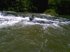
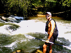
It was a good run, but it took much more time than we had thought. I had my GPS on to gauge our progress, but, the batteries died on it half-way through the trip. (Fortunately, my cell phone battery kept its charge, hence the photos above.) When we did get to the take-out, I was parched, and drank just about every potable substance we had available. However, we definitely chose the better of the two routes. As we looked toward the North Saluda where it entered the South, it was narrow and clogged with downed trees. As we suspected, we had to push the truck once again to start it.
When we got home, Laura had some interesting news. It seems that the Greenville Sheriff’s office and discovered my truck on the side of the road, and called her. After the initial panic, they asked if she knew where I was. She told them we were river-running and had left a vehicle, and they were Ok with that.
River Details:
Put In: Freeman Bridge Road. Lat. 35.001 Degrees N, Long. 82.5423782 W
Take Out: Hunts Bridge Road – turn right after crossing the bridge, and park where the road approaches the river, right before a sharp left turn. Lat. 34.9430537 N, Long. 82.5264225.
Difficulties: Mainly downed trees for first two miles. The river is mostly Class I riffles, with a couple of Class II rapids. Small rapids can be found at Lat. 34.9822782, Long. 82.5383394, and Lat. 34.9780945, Long. 82.5478981.
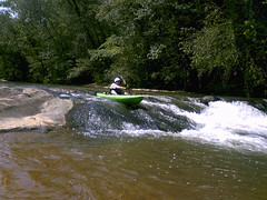
The first Class II is located at Lat. 34.9617309, Long. 82.5280531. The easier run is on the right, with sufficient water levels. On the left, the river flows over three foot drop, with a rock in the middle of the obvious route. Water sprays off of this rock like a fountain. There are possble routes to the right and left of the right, but it’s better to run this to the far right, close to the rocks in the middle of the river.
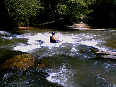
The second Class II is a series of shoals just after the confluence with the North Saluda, Lat. 34.9510107 Long. 82.5236344 . The route is on the right. The rapid may be run straight through all the way on the right, but the recommended route is to take a hard left over the small drop to line up for a nice little chute about 100 feet on down.
Wow man, I’ve been looking for others who have done this run. I used to run this section of Saluda several times a week since I lived off of Hunts Bridge Rd when I first started kayaking. We’ve always made up names for the two larger rapids on this river. The one with the rooster tail and the 3′ drop we called “Little Tablesaw” after the Tablesaw in Ocoee. The last one we’ve jokingly called it “Butt Crack.” That crack in the small drop facing river left catches MANY newer paddlers. That and the fast current it picks up making that left hand turn above the crack/drop make it a decent rapid I’ve always thought. I’m glad to see someone else has ran this.