My camera has the shakes. It’s a combination of high magnification and my cheap lenses. I’ve been experimenting with higher and higher levels of magnification, and I believe I’ve hit a limit. Even using a rock-solid tripod won’t help me with this.
My Celestron C90 is listed as a f/11, 1000mm lens when used with a T-mount. Since my Nikon D50 has a 1.5X magnification level, the telescope has an effective focal length of 1500mm. I’ve been able to get some fairly sharp shots, albeit with considerable effort. In an attempt to push the lens and camera to its limits, I added a 2X teleconverter, giving the rig an effective focal length of 3000mm. That’s pretty extreme.
As I mentioned, even using a tripod doesn’t seem to help with this setup. Regardless of length of exposure, the action of the shutter mirror moving out of the way of the shutter introduces a slight vibration, and that’s enough to reduce the sharpness of the image. I even used a remote shutter release, but it didn’t help. I think using a longer exposure might be better, because the shake would occur at the beginning of the shot, but would then stabilize for the rest of the exposure. I’ll have to experiment.
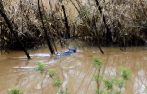
The T-mount for my Celestron isn’t the steadiest of of connections, so I’m sure that’s what’s contributing to the vibration. Therefore, I decided to try the 2X extender with my 70-210mm Sigma zoom lens. At its fullest extent, and with the tele-extender, the lens has an effective focal length of 430mm. The images were sharper than with the Celestron. However, shooting wildlife was nigh impossible, especially if it was moving at all. I tried shooting the heron, several ducks, and a beaver on our lake in late afternoon with cloudy skies. The image below was shot with the Sigma setup using my tripod.
I think I’ll try again today with brighter skies.
I have an idea. Find the lowest speed film you can. Close the aperture down as far as possible. Create your own shutter by placing a piece of cardboard in front of the lens. Set your shutter to “bulb”. Use your remote shutter release to hold the shutter open then move the cardboard out of the way and then back into place as quickly as possible. The trick would be getting the cardboard to cover the lens completely without touching it. The other trick would be moving the cardboard fast enough that it didn’t overexpose. You might have to add a neutral density filter to compensate for the slow shutter speed. I suspect you could simulate about 1/4 second shutter speed this way, meaning that on a bright sunny day, with 25 ASA film, and an ND9 filter, it would expose properly. On a cloudy day or in the shade you wouldn’t need the ND filter at all. This of course would all be completely impractical in the field but might be a fun experiment.
Now Tom I have a question for you about Google Earth. A couple weeks ago I spent the day walking trails on a friend’s property to create a map of their property for them. My GPS doesn’t have a function for downloading the waypoints into my computer so I inputted them all into Google Earth by hand, set place marks and copied and pasted that image into Photoshop. I then looked at the track log on my GPS and drew the trails connecting the various points. I then deleted the Google Earth image in my Photoshop file, turned off the place marks in Google Earth, copied and pasted the aerial shot into Photoshop again (without all the place marks) to use as the background image for the trail map. This took several hours. So my question is, is there an easier way to create trail maps using Google Earth? I read your last post about real time tracking using a laptop, but there’s no way that would have been practical in this situation. Another question I have, is there somewhere that lists what areas Google plans to update in the future. In the particular area where I was (near Brevard) the image map is really poor.
One more thing, have you seen this website: http://www.hostip.info/
It seems like the kind of site you might like.
Some cameras have a mirror lock up that might come in handy. Don’t know if your Nikon does or not. My Minolta has a motion stabilized sensor, but the consequence is sometimes a slightly softer focus on the image. The Minolta/Sony recommendation on my camera is not to use the stabilization while using a tripod, but I don’t see why not (except it’s normally not needed).