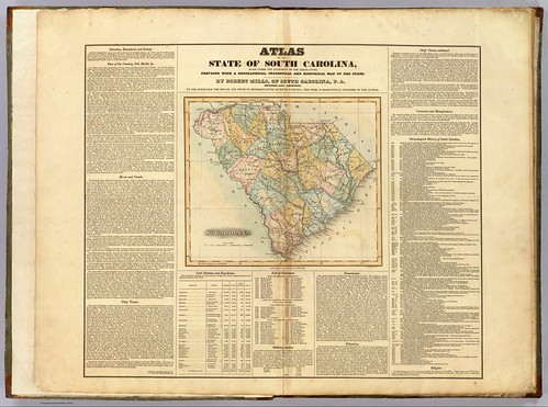
I was talking with my brother Houston sometime back about my Ghost Towns project, and he suggested that in addition to using the GNIS historical data, we should look at old maps of the state to see what towns might have been listed. I agreed that it was an excellent idea, so I set off in search of the one resource I knew would have everything we wanted – Robert Mills‘ 1825 Atlas of South Carolina.
A native of Charleston, Robert Mills was the quintessential Renaissance Man, along the same lines Thomas Jefferson. Mills studied architecture first in Charleston, then later in Philadelphia. Anyone familiar with South Carolina history is aware of Mill’s contributions to South Carolina – the many court houses and civic buildings designed by him. Perhaps, though, he is most famous for his designs for buildings in Washington, D. C., including the Washington Monument.
In 1818…
“…the General Assembly adopted resolutions looking to the preparation of a map of the state, showing a separate map of each district thereof. In 1818 an appropriation of $9,000.00 was made toward procuring such a map, and in 1819 a like amount was appropriated for the same cause.”
-from the Introduction to the 1839 reprint of the Mills Atlas.
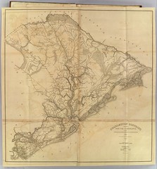
In 1820 Mills was appointed commissioner for the Board of Public Works for South Carolina, and was tasked with creating the atlas. He commissioned surveyors to create the separate maps for the then 27 districts in the state. He then personally rescaled the surveyors’ work for inclusion in the atlas, and added a legend reflecting the new scale. He also edited place names, adding or omitting as needed. The legend of each map bears the original surveyor’s name and notes the map was “improved for Mills’ Atlas, 1825.”
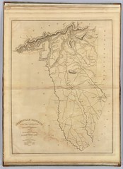
Mills’ Atlas was engraved and printed in Philadelphia by H. S. Tanner & Assistants, and was presented to the South Carolina Senate on September 29, 1826. It’s publication marked an American cartographic first. This volume is the first systematic atlas of any state in the union. Remarkably, too, no other state atlas of South Carolina was published for the next century and a half. Due to demand, a reprint of the Atlas was authorized in 1839.
So, exactly how might this help with the Ghost Towns project? The maps offer insight into place names and locations that might not exist. Some of these locations aren’t even in the GNIS database. This goes beyond place names, and includes the locations of many mills and other places of commercial importance. For example, there is a “Maj. Benson’s Mill” located just south of Travelers Rest and an “E. Green’s Tavern” located just east of Greenville. Other locations indicate the names of prominent residents. Even if the maps don’t reveal any new potential ghost towns, the insight into how current place names developed is wonderful.
In regards to my project, there are two problems with the Atlas. First, there’s the fact that this is 1825 accuracy, and not exactly GPS-ready. I attempted to overlay the maps on top of Google Earth, but just couldn’t get them to line up close enough to be of any use. For the most part, old road beds, towns, and other physical features are only going to be verified by direct physical observation.
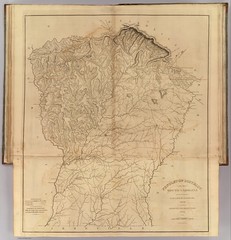
The second problem is with how the maps are made available digitally. Individual paper reproductions are available from the South Carolina Department of Archives. I was able to find to complete versions online. The University of South Carolina has the 1839 reproduction available. Smith College has the original 1825 Atlas as part of their David Rumsey Map Collection.
The problem is that neither of these sites allows download of full resolution images. Both only offer views that zoom in to such an extent that you lose context. Navigation is not easy. I was able to download images from the Smith College collection and rehost as a set on my Flickr account. However, these don’t have the resolution to view the small print, either.
I guess a trek to the library is in order to view the full-sized maps. Until then I’ll make what use I can of the online images, and see if I can discover some new target for our South Carolina adventures.
References and further reading:
- Robert Mills on Wikipedia
- David Rumsey Map Collection at Smith College, Newhampton, Massachusetts
- 1839 Robert Mills Atlas – University of South Carolina Library Digital Collection
- South Carolina Historical County Lines
- Mills 1825 Atlas – Flickr collection
I want to say that Greer Public Library has one of these, it’s pretty cool.
The resolution issue was a problem for me too. Seems a shame to have a nice, hi res screen of 24 or so inches, but not be able t see the detail sufficiently to be useful. This was the problem with the first few editions of the digitized National Geographic as well. Frustrating.
Pher – that’s good to know. I figured the libraries would have a copy since the State Archives are making them available for purchase. I’ll have to run by there sometime.
This atlas has helped alot. I own a piece of property on the south tyger river and believe one of the old mills concrete foundation for the water wheel is on it.
I have been trying to find out what it is thought it was for an old road or possible abandoned rail way
How can we find out what type of mills they were in their glory days?
In this case “Mills” is the last name of the publisher of the atlas – Robert Mills. It doesn’t refer to an actual mill.
I understood that. I guess my question was unclear. I was asking for advice on how to find more information on historical textile mills in general in Greenville, SC. In other words in your experience what are good sources to start with? (Mesuem archives, National Register of Historic Places, etc.)
You can find the maps at the Library of Congress Website. Some of them from the original surveyors. Their map collection is extensive…
Link below, Carolina as a search term.
https://www.loc.gov/maps/?q=carolina&fa=location%3Asouth+carolina&st=list&c=150