Today I found out from Frank Taylor’s Google Earth Blog that Google has released version 5 of Google Earth. I had to run out and update my copies of the program right away.
At first glance there doesn’t appear to be much different. The buttons are altered slightly but the overall user interface hasn’t changed. However, there’s quite a bit new in this release, most of it under the surface (literally.)
The brand-new flashier bits in this version are as follows:
Google Ocean – greater details of the ocean floor had already worked their way into the last release of version 4. However, now users can plunge beneath the water’s surface to explore. A new folder of points of interest has been added to accompany the new feature.
Google Mars – Now users can switch between Earth, Sky, and Mars. The imagery is quite impressive. However, make sure that you de-select any of your terrestrial layers. It was a bit disconcerting to see earth-bound geotagged Flickr images on Mars.
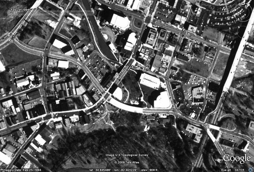
Historical Images – To me, this is one of the coolest new features. When activated from a button on the tool bar, a slider appears. If there are any historical images of that location, slide the bar to the left to view them. It’s great for tracking changes over time. For example, here’s a view of the Reedy Falls Park area from 1994, prior to construction of the Liberty Bridge and Falls Place…
…and here is the current view…
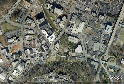
I would love to be able to use this in a classroom again. I don’t know how many places have historical data available or how far back it goes, but even the fifteen-year difference shown here is impressive.
As impressive as these new features are, there are two that aren’t really new at all that will make a good deal of difference to me. They just haven’t been available to mere mortals (read, “cheap”) as myself. Both of these have been available in one form or another in either the now-defunct Google Earth Plus or Google Earth Pro from the beginning. Now they are available in the standard version.
The first of these features is the ability to get real-time updates from GPS. In the past you could open a GPX file, and you can still do that. However, now there is a new interface that allows direct import of tracks from a GPS unit, as well as real-time position updates. The updates can even create a path on the fly. I haven’t tried it, and I rarely have Google Earth in a situation where it makes sense to update in real time, but it looks pretty cool.
The second feature is the ability to create even more interactive tours with audio narration. This goes far beyond the previous tour capability, which would only track along a specific set of placemarks. The new version records any change in view, including zooming and eye level. The result is more cinematic. The only difference between this and the pay versions is the ability to export to a video file such as an AVI file. I may see if some screen capture program might compensate for that, though.
I haven’t had much time to play with the new version, but it does look intriguing. I guess now I’ll have to redo all my handouts for all of my Google Earth workshops.
Cool. The historical images feature sounds really cool. On the park, it’s a shame they don’t have imagery from further back, like the pre-Peace Center days. I’ll have to check out how far back it goes.