Skip to content

Random Connections

A collection of photography and exploration focusing on Upstate South Carolina and beyond.

  • Home
  • About Us
  • Photos
  • Resources
  • Other Voices
  • Post Archives
  • Podcast
  • Home
  • Travel
  • From Townsend to Cumberland Gap

From Townsend to Cumberland Gap

Posted on June 5, 2007 By Tom No Comments on From Townsend to Cumberland Gap
Travel

On Google Earth and my old topo maps, Eastern Tennessee is lined with long mountain ridges and long valleys, running diagonally from southwest to northeast. These are the "wrinkles" were created when the Smokey Mountain Thrust Sheet slammed into the area millions of years ago. Our plan was to try to get to the Cumberland Gap area of Kentucky, crossing some of this interesting topology along the way.

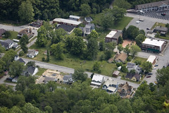
Our tour of Tuckaleechee took most of the morning. By just about lunch time, we were leaving the Townsend area away from the Smokeys and toward Maryville. The brief bit we saw of Maryville made it look like an interesting place, perched atop a couple of the aforementioned ridges. From there we headed north toward Knoxville. All-in-all, I have enjoyed every trip I’ve taken to Knoxville. However, this time our route seemed to take us through the seedier parts of the city.

From Knoxville we continued northeast along state route 33 until we got to Tazeville. A quick late lunch at Tazeville, and it was north on 25E to the Cumberland Gap. We drove through the small town of Cumberland Gap, Tennessee, then through the tunnel into Kentucky.

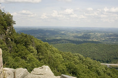
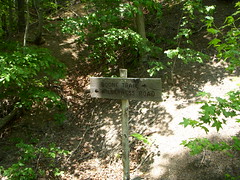
I guess my interest in this area comes from watching Daniel Boone as a kid, and reading his biography. I was amused that all of the depictions in the Cumberland Gap Visitors Center bore a faint resemblance to Fess Parker. From the Visitors Center, we took the four-mile drive up to the Pinnacle, which overlooks the Gap and the surrounding area. The views were incredible.


Post navigation

❮ Previous Post: Tuckaleechee Caverns
Next Post: Cumberland Falls ❯

Leave a Reply Cancel reply

Your email address will not be published. Required fields are marked *

This site uses Akismet to reduce spam. Learn how your comment data is processed.

Categories

  • EdTech (197)
  • Entertainment (201)
  • Family (123)
  • Gear (114)
  • General Technology (98)
  • Geocaching and Maps (208)
  • History and Genealogy (275)
  • Internet (141)
  • Local (458)
  • Miscellaneous (557)
  • Music (202)
  • Paddling (265)
  • Photography (781)
  • Podcast (17)
  • Rambling (233)
  • Rants (161)
  • Recipes (36)
  • Religion (48)
  • Restaurants (165)
  • Science (48)
  • Things Overheard (29)
  • Travel (413)
  • Uncategorized (143)
  • Washington Sabbatical (113)
  • Weirdness (59)

Recent Posts

  • Carolina Ghost Towns – Mitchellville
  • Carolina Ghost Towns – Paper Towns
  • Kayaking on Wolf Creek Lake
  • Carolina Ghost Towns – Colonial Dorchester
  • Six Layer Bourbon Grits Bowl

Recent Comments

  • Eric Kincaid on Kayaking and Coffee
  • Daniel S Mawn on Remembering the Walke
  • Judy Hall on The Clock on Wade Hampton
  • Charles Johnson on In Search of the Road Builder
  • Anthony h hannig on From Kingsbury to Stoneboro – Rambling in Lancaster County

Tags

blogging cemetery Christmas Columbia Edisto River edtech Entertainment family Flickr Florida Furman Furman University gear Georgia geotagging Ghost Town Ghost Towns Google Earth Google Maps GPS Greenville Greenville Chorale history Instructional Technology kayaking Lake Jocassee LCU Lowcountry Unfiltered maps Music North Carolina Paddling Photography rambling restaurant Restaurants review singing social networking South Carolina time-lapse Travel video Washington Washington State
June 2025
S M T W T F S
1234567
891011121314
15161718192021
22232425262728
2930  
« May    

Copyright © 2025 Random Connections.

Theme: Oceanly by ScriptsTown