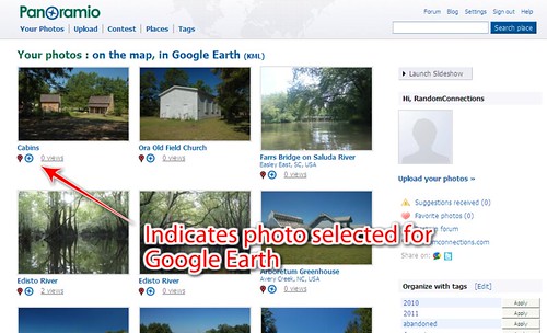
I finally caved in. I’ve been uploading some selected photographs to Panoramio so that they will appear in the Google Earth Photos layer. As of this writing I have 121 photographs that have been selected to appear in Google Earth, and I’ve submitted more that are awaiting approval.
If you’ve got a Google account, then you can use that to sign into Panoramio and create an account. Photos are uploaded just like they are to any other photo sharing site. Just make sure that your photos are geotagged. Even if they haven’t been geotagged previously, there is a drag-n-drop map so you can locate your photos once they have been uploaded.
Panoramio has some specific guidelines for approval for Google Earth. There are the usual conditions – no pornography, discriminative, or abusive photos. However, there are some other guidelines. They are looking for photos that illustrate a place, so images of people, events, or detailed images of flowers or other items may not be approved. Likewise, interior shots probably won’t be selected for Google Earth.
For Google Earth and Google Maps we select only photos about exterior places: landscapes, monuments, streets, buildings, parks, and so on. All photos must comply with the Panoramio Photo Acceptance Policy.
I know I’m coming to the Panoramio game quite late. Part of this was because I was already so involved with Flickr and I didn’t want to get bogged down with multiple photo-sharing sites. The social networking aspects of Flickr are much more robust that Panoramio, and it’s much more cost effective. With the pro version I’ve got unlimited storage on Flickr, while Panoramio charges an incremental amount for increased storage about its free versions.
Flickr supports mapping and geotagging, but nowhere near as well as Panoramio does. Flickr’s KML output is limited to the last 20 photographs uploaded. There is no way to view your entire photostream in one Google Earth file. There is also no way to easily browse other Flickr users’ geotagged photos in Google Earth. There used to be some good third-party applications that did this, such as the now-defunct Metal Toad KML layer. However, even these are getting harder to find.
So, Metal Toad and others offline, and with Flickr not wanting to play nicely with its parent company’s rival, I went looking for alternatives. It was time to check out Panoramio.
Over the past couple of years Panoramio has increased the number of photographs it has been approving for Google Earth. That means that popular tourist areas can be super-saturated with photos, making the area overly crowded with image links. For example, here is the Biltmore House with the photo layer turned on…

Each square represents an approved, geotagged photo from Panoramio.
There are some much better photographers out there, and I didn’t want my photos lost in the clutter. For my initial foray into Panoramio I tried to find photos for areas that didn’t have huge numbers of images already approved for Google Earth.
This wasn’t easy. Some Panoramio users have been quite active. I’ve been impressed particularly with the work of photographer BearDen82. He has 1720 photos in Google Earth, and has covered South Carolina very well. He also appears to be an avid paddler, and many of his photographs are of rivers and waterways in the state.
I picked out a nice selection of photos from my Flickr collection and tagged them with the word “panoramio”. I then used the Saleen Flickr Downloader to batch download the photos I had tagged. Alternately, I could have selected photos directly from my hard drive and uploaded them to Panoramio. However, I was doing this on my laptop instead of my Mac where I have all my photos, and I had geotagged some photos only in Flickr using their mapping system, and not on the photos themselves. (More on that in a bit.)
The uploader on the Panoramio website only allows for ten photos at a time, which is a pain. I know there is a plugin for Picasa, and there may be a stand-alone batch uploader, but I haven’t really looked for or played with them yet. Soon enough, though, I had a nice batch of photos on Flickr.
I’m not sure how often photos are reviewed for inclusion on Google Earth, but for me it happened rather quickly for all of the batches I submitted. There were some that weren’t approved, such as a boat that didn’t really show the context of the location…
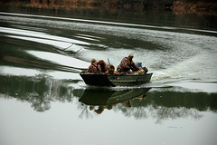
…but I can understand that reasoning.
One of the biggest problems I had was location data not transferring over from Flickr. I found that if I had geotagged the photo on my computer, writing to the EXIF data, there wasn’t a problem. The location data transferred with no problem. However, if I had added the location data within Flickr itself using their mapping system, that data did not transfer, and I had to re-map the image in Panoramio. I haven’t tried it, but it would be interesting to see if images that were mapped in Panoramio after uploading retained their location data – ie, does it write to EXIF?
So, am I going to switch completely from Flickr to Panoramio? Not likely, despite some of the bad press Flickr has received lately for deleting accounts. I have nearly 12,000 images on Flickr, and have invested too much time and effort in that system. My only intent was to see if I could get some of my photos included in the Google Earth photo layer, and that has been successful. I may try adding more, but the free version of Panoramio doesn’t give me enough space for ALL the geotagged images I’d like to include from Flickr.
Storage quota in Panoramio is unlimited and max photo size is 25Mbytes/50Mpixels and that is free:
http://blog.panoramio.com/2010/09/photo-size-and-storage-quota.html
You may have confused costs with Picasa Web Albums were 1GB is free and after that there is a subscription cost:
http://picasa.google.com/support/bin/answer.py?hl=en&answer=39567
If there is unlimited storage, then perhaps you guys need to change the text on your login screen. It would seem to indicate that only 2 GB of storage is free…
Thanks Tom, we realized after reading your post. We will fix this asap, thanks for your feedback.
Thanks Tom, we realized about this issue in documentation just after reading your post. It will be fixed asap.
your photos selected for goole earth will not b in the storage quota.
Good post Tom. I have hundreds of photos on Flickr but would like some of them to appear in Google Maps.
The thought of migrating those photos to Panoramio is just too difficult to consider, even though I generally use Picasa to edit (crop) the photos before uploading to Flickr.
Have you reconsidered the migration since this article?
Bradley – the advent of Google+ made me think about it a bit more, but I still have some concerns. Google wants full-sized images. However, the security measures for Panoramio are non-existent. I guess if I were to re-size and somehow digitally sign the EXIF data it would be a bit better. I may yet do that for some images.
Flickr’s got problems, no doubt. It’s outdated and its user interface is the pits. However, for the price nothing beats it as a long-term digital storage for images. Google+ automatically resizes your images, so you can’t store the original size online. Even then, it suffers from the same security problems as Panoramio.
Tom,
You don’t need to download your pictures to migrate from FlickR to Panoramio.
Use MigratR (http://www.callingshotgun.net/about/migratr/) to migrate from FlickR to Picasa. In Picasa, there is an option to migrate to Panoramio.
Good luck!
I also migrated from Flickr to Panoramio, mainly for the reason that the mapping on Flickr was so poor, and no one ever saw my pictures, but with Panoramio, I can reach a much wider audience on Google Earth/Maps.
I too only post photos in places where other photos have not already been places.
I spent extensive time in remote, rural areas or Yunnan province, China, and I’ve been able to add hundreds of photos in unique locations where no photos existed before.
Thanks for the favorable mention in this blog! I’ve seen you have some nice photographs on Google Earth.