I dropped Laura off at the airport for a far-too-early flight, then headed out for a day of exploring and photography. The day started off with rain, and I was afraid that I wouldn’t be able to get many shots. However, it soon cleared, and I set out.
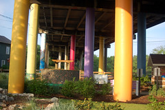
 My first stop was the Linky Stone Park, located under an overpass on the banks of the Reedy River. The park has been done in bright colors, and a children’s storybook garden has been created. There were tons of flowers in bloom, so I used the early morning light with my macro and close-up lenses for some shots:
That red cone flower has become my fourth picture selected for the Nikon Stunning Gallery. It was on the Nikon site less than half an hour after I uploaded it to Flickr.
Depending on how the weather held out, my plan was to make my way down the Saluda River, eventually winding up in Ware Shoals. Last weekend there was supposed to be a whitewater event in that small town. The local company that controls the dam on the river was going to do a water release, creating a mile-long stretch of whitewater that had never been kayaked. The event was cancelled due to low water levels, but I wanted to see what had been the potential.
My first stop was in Piedmont, South Carolina. This is one of those ubiquitous southern towns that grew up around a textile mill situated on a river. As with most, the textiles are long gone, and the town is scratching out an existence. There was an interesting little downtown area consisting a few storefronts right on the river. It was obvious that the river went over a small dam, but I couldn’t see any way to get to the river. Frustrated, I took a few shots of the storefronts.
I continued down the Piedmont Highway to the three towns of Pelzer, West Pelzer, and Williamston. I stopped briefly at the Mineral Springs Park, but didn’t linger because a class of students was unloading for an outing. Once again I crossed the Saluda at West Pelzer. I was able to drive closer to the river, and there were access points, but none with good shots of the dam and accompanying falls. As with Piedmont, the textile mill had long since closed.
With a brief detour by Beech Springs Campground – the church Bible camp I attended during summers while growing up, I eventually made my way to Fork Shoals on the Reedy River. Once again, there was a river, an abandoned mill, a dam with water flowing over, and absolutely no way to get to any of it for a photo.
Except for the river area, this whole town looks depressed. I took pictures of the boarded up Ware Shoals Inn and Armory, then went in search of the river.
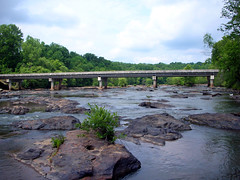
Ware Shoals has developed a nice little park at its namesake. I probably could have navigated the waters in my kayak, even without the dam release and with low water. However, I was able to wander far out into the river without getting feet wet by jumping from rock to rock.
I took Highway 252 back to the Reedy River, and to Boyd’s Mill Pond. You guess it – another dam-mill-falls combination. By this time I was getting tired and I had missed lunch, so I headed back toward Greenville on country roads, with one more stop on the Reedy in mind.
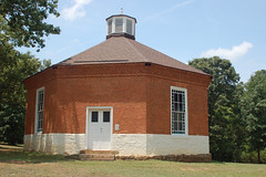
Reaching Mauldin, I turned west toward Connestee. This time I wasn’t as interested in the dam-mill-falls combination that creates Lake Connestee. Instead, I was after McBee Chapel. This tiny octagonal Methodist Church still holds services. I may have to sneak by here one Sunday.
And finally, I see a limitation of my "It Happened Here" geotagging for posts. It only shows one point, and, not a path. Each of the images above has been geotagged in Flickr, with links to the maps.


