Skip to content

Random Connections

A collection of photography and exploration focusing on Upstate South Carolina and beyond.

  • Home
  • About Us
  • Photos
  • Resources
  • Other Voices
  • Post Archives
  • Podcast
  • Home
  • 2012
  • February
  • 12

Day: February 12, 2012

Kingville, Kingsville

Posted on February 12, 2012 By Tom 23 Comments on Kingville, Kingsville
Geocaching and Maps, History and Genealogy

Kingville Station

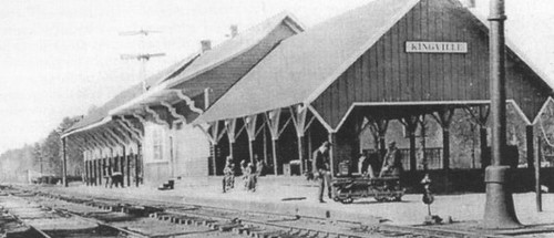
I came upon Kingville quite by accident. I was looking for information on another ghost town in Google Earth when I spotted this name near the confluence of the Congaree and Wateree Rivers. When I zoomed in a bit further I saw that the the place indicated by the name was all wooded – there was no town there. Street View also showed just a wooded area, and not enough buildings to even justify keeping this as a place name. This intrigued me, so I did a bit of research, and it turned out to be an interesting ghost town location itself.

Kingville Google Earth

According to information on the Kingville Historical Foundation’s website, the town got it’s start in 1842 when a spur railroad line from Aiken was completed to Columbia. I checked Robert Mill’s 1825 atlas of the area, and the name Kingville does not appear. In 1850 a branch line was completed to Camden, and the town began to grow because it was now located at the juncture of two major railroad lines.

Research on the town was initially confusing. According to the historical marker for the site…

Kingville is thought to be named for its status as “king” of the railroad line between Charleston and Columbia and between Columbia and Camden.

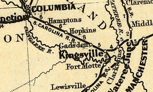
However, the town was first called “Kingsville” with an “s”. For awhile I wasn’t sure if I was finding information on the same town. For example, this is an excerpt from an 1870 map of the Port Royal railroad in the southern states. It clearly shows the spelling with an “s”. The town’s name on this map makes it look almost as big as Columbia, but this is deceptive. Since this was a railroad map, the emphasis was on major junctions, rather than the actual towns.

Kingville_1870

Read More “Kingville, Kingsville” »

Congaree and Lower Richland

Posted on February 12, 2012 By Tom No Comments on Congaree and Lower Richland
Geocaching and Maps, History and Genealogy, Local, Travel

Starting out on the Congaree Boardwalk

Normally on a second Saturday I’d be off with the guys from Lowcountry Unfiltered. They had a great trip planned for today, but due to various reasons I wasn’t going to be able to join them. Instead, I teamed up with Dwight, his wife Sue, and son Adam to explore Congaree National Park and a bit of Lower Richland County.

Lower Richland County is located in a wedge formed by the Congaree and Wateree Rivers up to their confluence, where they become the Santee River. The area is also known as the “Cowasee” Basin, a name created by combining names of those rivers. Congaree National Park makes up most of the Cowasee Basin, but there are also lots of historical locations, including one interesting ghost town.

I headed down to Congaree on this clear, cool Saturday morning. I arrived at the park early to find an already packed parking lot. There were groups of Boy Scouts, as well as other tour groups gathering. I have to admit – I tend to be selfish with my wilderness experiences. I don’t mind others around, but lots of loud people make it hard to see wildlife. I was a bit worried.

Congaree Crowds Gather

Dwight, Sue, and Adam arrived, and soon we were off, headed down the high boardwalk. The plan was fairly simple. We would stick to the trails and boardwalks for the most part, but we wanted to do a little bushwhacking. We also wanted to find at least one champion tree.

Read More “Congaree and Lower Richland” »

Categories

  • EdTech (197)
  • Entertainment (202)
  • Family (123)
  • Gear (114)
  • General Technology (98)
  • Geocaching and Maps (208)
  • History and Genealogy (275)
  • Internet (142)
  • Local (459)
  • Miscellaneous (560)
  • Music (202)
  • Paddling (268)
  • Photography (781)
  • Podcast (19)
  • Rambling (233)
  • Rants (162)
  • Recipes (37)
  • Religion (48)
  • Restaurants (165)
  • Science (48)
  • Things Overheard (29)
  • Travel (413)
  • Uncategorized (143)
  • Washington Sabbatical (113)
  • Weirdness (61)

Recent Posts

  • Helene One Year Later
  • Once Again, Up the Long Nose
  • Upstate Renaissance Faire
  • Exploring Lake Summit
  • The End of Days

Recent Comments

  • Gay on In Search of the Road Builder
  • Virgil Howell on The Ghost Towns of Lake Marion
  • Virgil Howell on Return to Ferguson
  • Mary Copeland Myers on Renno and Stomp Springs
  • Virginia Pepper on Helene One Year Later

Tags

blogging cemetery Christmas Columbia Edisto River edtech Entertainment family Flickr Florida Furman Furman University gear Georgia geotagging Ghost Town Ghost Towns Google Earth Google Maps GPS Greenville Greenville Chorale history Instructional Technology kayaking Lake Jocassee LCU Lowcountry Unfiltered maps Music North Carolina Paddling Photography rambling restaurant Restaurants review singing social networking South Carolina time-lapse Travel video Washington Washington State
February 2012
S M T W T F S
 1234
567891011
12131415161718
19202122232425
26272829  
« Jan   Mar »

Copyright © 2025 Random Connections.

Theme: Oceanly by ScriptsTown