I’d made it through Allendale County, my GPS beeping every time I reached the location of an old tourist spot that I had marked. I was following the Tobacco Trail through South Carolina on Highway 301. Now I had just crossed the Salkehatchie River into Bamberg County.
Highway 301 crosses the Salkehatchie at Buford’s Bridge, and this community is known by that name. This is one of the oldest communities in Bamberg County, having been settled as early as 1792. William Buford operated a ferry here, and the bridge took his name.
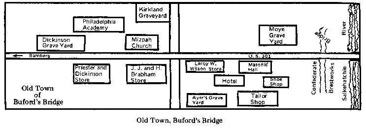
Even before the Tobacco Trail this was an important route. At one time the community boasted several residences, four stores, two taverns, a boarding house, and a Masonic lodge. According to a historical marker on the site, in 1865 Confederate soldiers burned the bridge to prevent a unit of Sherman’s forces from reaching Columbia. The Union soldiers were still able to cross the Salkehatchie, and burned the residences and commercial buildings.
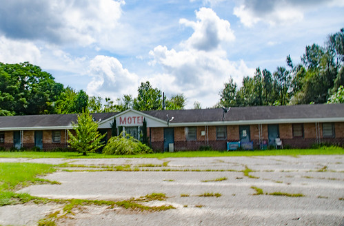
Now there are a couple residences here, but the standouts are a couple of former tourist locations. Right where 321 and 301 divide there is an old convenience store now serving as a motorcycle repair shop. Next to that is the old Motel Connelly.
The fastest way for me to get home from this point, and the usual route I take, is to branch off at 321 and head toward Columbia. However, I still had plenty more of 301 to explore. Just past that intersection is the old Mizpah Methodist Church. This was one of the only buildings left standing by the Union forces, and it is now on the National Register of Historic Places.
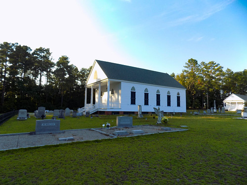
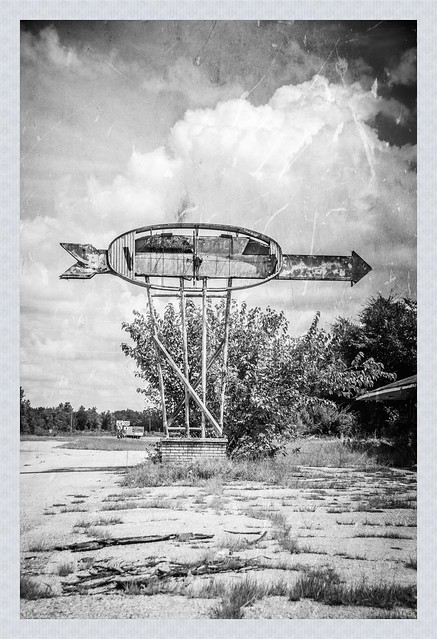
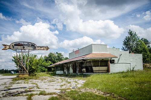
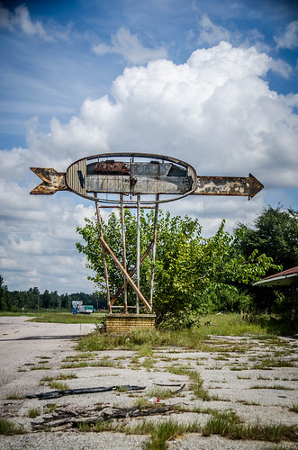
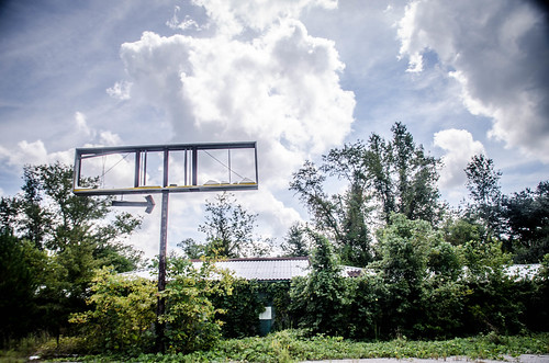
Larry Easler and I had stopped to explore the church and cemetery on our way back from the Savannah River a couple of weeks ago, so I didn’t stop this time. Major intersections are key. If you can locate your motel/service station/whatever near an intersection, you increase the amount of traffic that passes your site. Such was the case with the Tobacco Road. At the intersection of 301 and state 64 headed toward Olar I found this former service station. I was especially drawn toward the old sign.
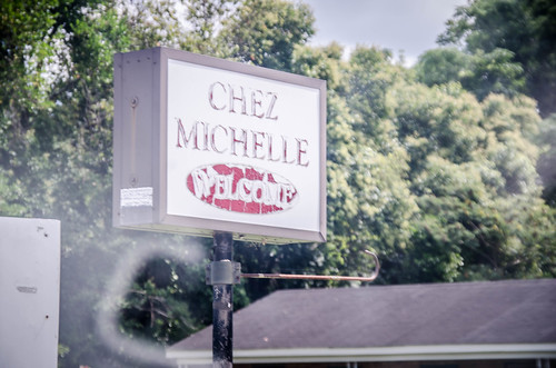
There were more miles of farmland, then I reached the Glendale Springs community. Here there were several remnants. The Chez Michelle certainly looked like it had seen better days.
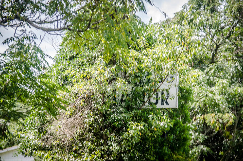
I had one more motel marked just a couple of houses over. I’m still not sure if it’s a motel, but it had a sign with the word “manor” on it. It might have started life as a motel, then become an assisted living place. Checking Street View revealed the name “Carrigg Manor,” and a quick Google search confirmed this to be the case.
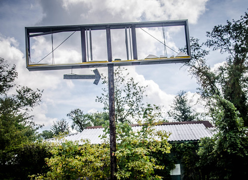
Regardless, it doesn’t look like it’s in use now. The sign was completely overgrown, and the chain link fence was collapsing. A bit further along was an old store. There had been gas pumps, and it was probably a service station. There was only a frame where the sign had been.
A few more miles and and I reached the town of Bamberg. It struck me as just as desolate as Allendale. The town had been making an attempt at revitalization, but they just weren’t there yet. When Larry and I drove down earlier, the parking lot in front of an abandoned Piggly Wiggly has been set up for a tent revival. There was no sign of it now. It’s a shame. We almost stopped that night – the preacher was quite animated and really telling his congregation what for.
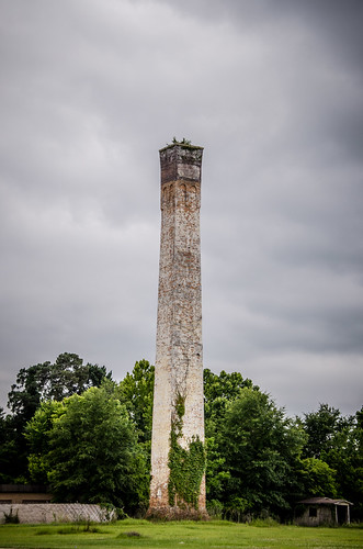
There are lots of old buildings for enthusiasts of the abandoned in this town. Some of these photos are from a previous visit I made during my Small Towns Tour of a couple of years ago. An old smokestack with plants growing on top marks the south end of the town.
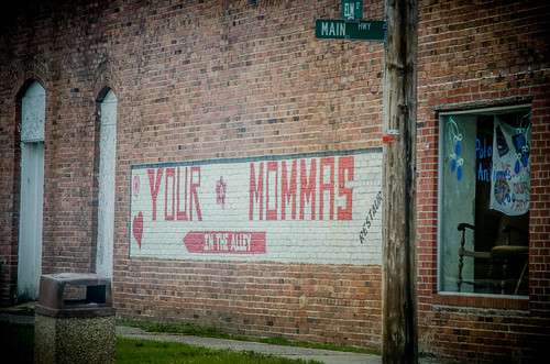
An intriguing sign greets visitors to the downtown. It was just past lunch time, but I wasn’t tempted to try it. Maybe next time.
It looks like Bamberg had a problem – the main street was too narrow. The solution was to widen the highway right up to the edges of the sidewalk, then add fencing to protect pedestrians. There is no on-street parking.
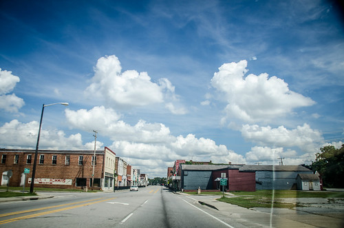
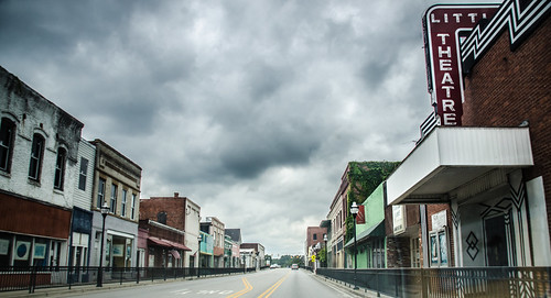
There is some interesting architecture, but overall it looks like the downtown doesn’t have too many occupied businesses.

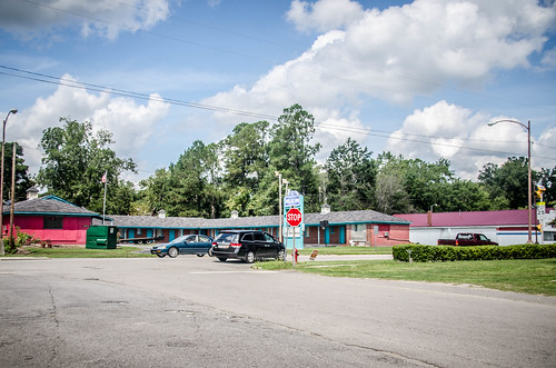
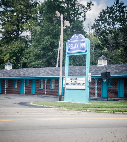
The north end of town is where things get interesting, as for as tourism is concerned. I had the Relax Inn marked in my GPS. Looks like it is still in business.
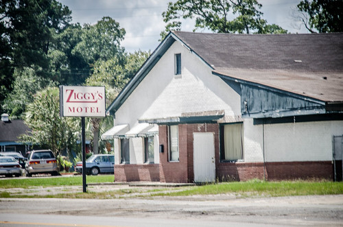
Just up the street was Ziggy’s Motel. The name itself grabs your attention. I had several postcards from this location that I found on eBay, and one matchbook.

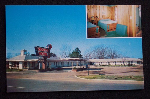
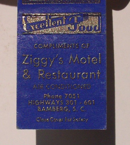
It looks like the office with a cupola on top was either removed, or a second floor was added. The curved Vacancy sign is still there, but the part that says “Ziggy’s” is gone.
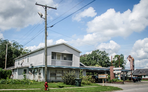
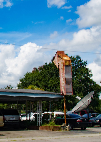
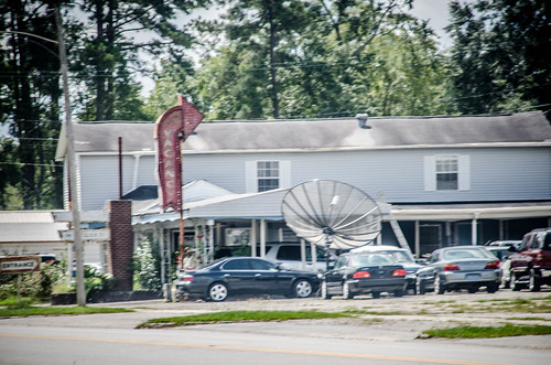
Instead of a motel, it’s now a used car lot. There is a sign outside of the old restaurant that still says “Ziggy’s Motel.”
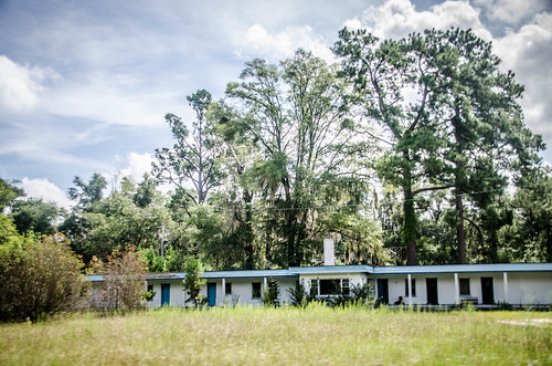
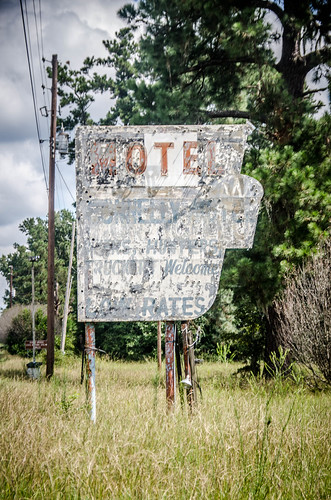
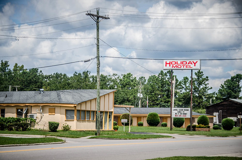
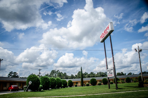
Next door to Ziggy’s is the Holiday Motel. This one seems like it’s still in business. Here’s an old postcard. There’s no date, but from the vehicles I’d say the photos were taken in the early to mid 1960s.
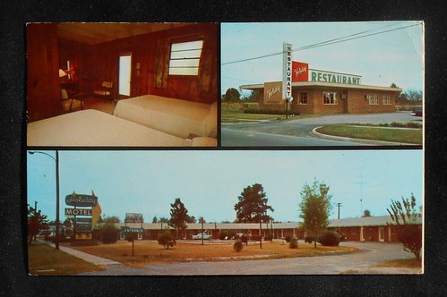
The sign is certainly different, and it looks like the restaurant is completely gone.
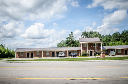
Further out on 301 I found another one of those motels with a central office and wings to either side. I’m thinking these were built by the same company. This one appeared to be subdivided into individual businesses somehow.
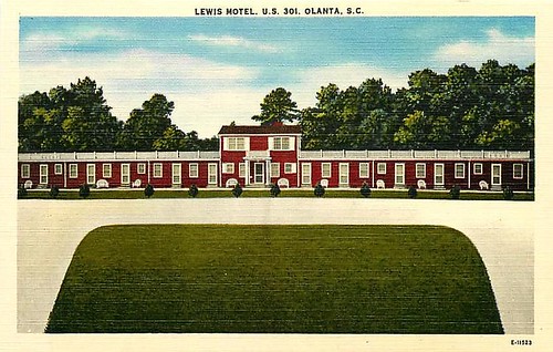
Once again, here’s the Lewis Motel in Olanta for comparison.
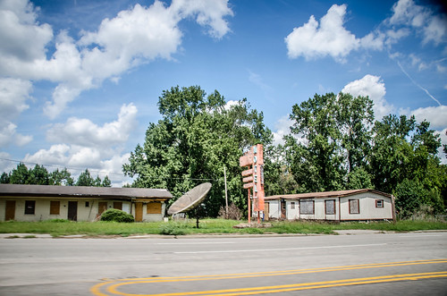
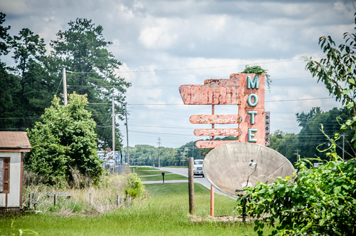
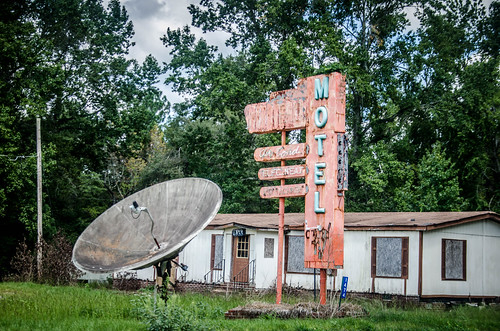
About a mile on out I came to the last motel in Bamberg County. This one was small, but had been closed for a very long time. A rather unique sign and satellite dish remained out front.
In just a couple more miles I would cross the South Edisto River into Orangeburg County. However, the time crunch was now critical. You may have noticed that those last photographs were rather rushed. I couldn’t spend much time.
My uncle John Snellgrove was ill with a failing heart, and as I was out exploring I got word that he was not expected to last through the day. Many of my family had already gathered to be with my Aunt Nina Ruth in Lexington, so I set my course in that direction as well. While I drove through Orangeburg and snapped a few photos along the way, I didn’t do them justice, and plan to come back down and do all of Orangeburg County in a week or so.
I arrived at my aunt and uncle’s home in Lexington in time to say my goodbyes to my Uncle John, and to be with my aunt for a bit. She was exhausted and in need of a nap, so I left. He would pass about an hour after I left their house. Uncle John was 91. In this case, cutting my trip short was certainly the right thing to do. Old motels along the Tobacco Trail will still be there when I’m ready to get back on the road.
Good morning, Tom.
Your posts re: Rte. 301 have proven both interesting and valuable in IDing the many photos I took yesterday, as I too retraced the Trail from the Savannah north to above Orangeburg.
I was able to uncover the name of that final motel before the Bamberg County line. It’s the Nightfall motel. These forms seldom include a way to attach a photo for visual confirmation, but should you acknowledge this I can certainly send it along.
And with your permission…similarly if I hit a wall on IDing something I shot.
Great work! Thanks!
I was in Bamberg last year (2020) and photographed the Nightfall Motel sign. The buildings were completely gone. I was able to ID the name on the sign only now, with some guessing about what the neon letters were hidden under the vines.
My grandparents used to run the Pioneer Motel on 301 just South of Bamberg. Years later, it did become a nursing home called Carrigg Manor.
The old nearby store was once a B.Loyd’s Pecan Store. They sold pecan candies, Claxton fruitcakes, moccasins, souvenirs, snacks, gold drinks, and fireworks. My grandparents left the motel and ran the store for some years past retirement age. B. Lloyd’s sold the store. It was run as a local convenience store of sorts for awhile by my grandparents before it was sold. The new owners used it for storage and later abandoned it.