When I mention Saluda Lake to my acquaintances, many don’t even know it exists. They usually reply, “Don’t you mean the Saluda River?” Or, they try to correct me by naming one of the many other lakes fed by the Saluda. Most don’t seem to be aware that there is a rather large lake on the west side of Greenville with that name.
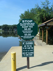
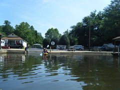
I can see why Saluda Lake is overlooked. While it’s a nice lake, the banks are almost completely built up, and there is very little public access. There is limited access right at the dam, but no place where one could easily launch a boat. The only boat ramp is on the north end of the lake on Motor Boat Club Road. It’s privately owned, and the signs make you think the owners are somewhat less that friendly.
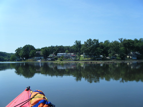
Despite the limited access, Alan and I decided to give it a shot. The lake is relatively close, and I’d never been on it. The plan was to put in at the one boat ramp then paddle north up the Saluda River to at least Farr’s Bridge on Highway 183. For a variety of reasons, we didn’t quite make it that far.
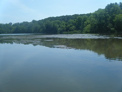
As soon as you put in you have to take a major detour. Siltation is very bad on the lake, and a large sandbar extends from a point on the right bank far out into the lake. We couldn’t even get over it with shallow draft kayaks. This wasn’t so bad heading out, but coming back when we were tired it was not a good thing.
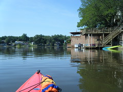
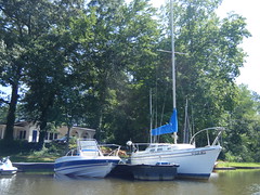
I knew there were boats on this lake, but I was surprised at the size of some of them. There were ski boats and pontoon boats, but I didn’t expect the huge cabin sailboats. This just seemed like overkill for this tiny lake.
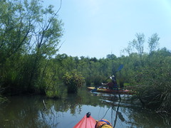
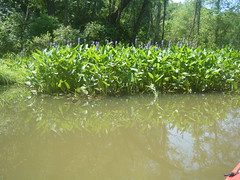
We headed upstream as planned. A narrow channel followed the houses along the right bank, but it looked like the main body of the lake extended on the left side, just past another silted area. This silted area was much more substantial, and had trees and little passageways we could explore.
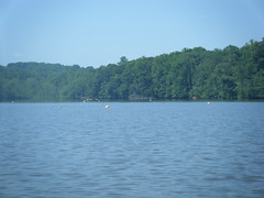
As we paddled down the main part of the lake we came across some red buoys. These appeared to be in two straight parallel lines, as if they were marking a runway.
We continued on past a very shallow section and came to the end of the lake, but…no river. There was a narrow passageway that was finally choked off entirely, but there was not anything that looked wide enough to be the Saluda River.
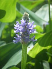
We paddled past a plant Alan identified as blue pickerel rush, then headed back the way we came.
We searched a bit more for the hidden river, but by this time the heat was really starting to get to me. I was totally exhausted from the past couple of weeks, and not feeling very well. I just barely managed to make it back to the ramp, but I did pause to take a shot of a pig with a rebel flag and a cannon.
We took one last detour after loading up the boats. Alan hadn’t seen the dam, so we headed down that way for a brief look. When we did get home I discovered two things. First, I was running a fever of over 100 degrees, and secondly we should have taken the narrow channel that hugged the east side of the lake. That’s where the river comes in.

I’m not sure I got a good feel for the lake on this trip. There were parts of it that were more remote than I imagined, but there were also larger boats than I thought the lake could handle. Both Lakes Cunningham and Robinson are larger than this, and they have motor restrictions. With jets skis and motor boats, this place could get treacherous to paddle. Then again, it could be too shallow for these boats to operate any more. I’ll have to come back when I feel better.
I wish that lake, and some others, could be dredged out and restored. Although the area at the head of the lake would make good wetlands habitat.
Tough call. We’ve got the same problem with the little lake behind our house. We like the habitat, but it would be nice if the lake could be restored to its original boundaries.
Probably the biggest challenge is paying for it. My inclination is to want to see the lakes dredged in order to fit their original purpose, but the habitat creation is something that shouldn’t be ignored. A tough but widespread issue for sure.
My youngest brother lives on Lake Blalock NE of Spartanburg. GREAT lake, as there are limits on boat size and power, and plenty of nice, deep water. The Paccolet River comes in from the NW, as does a large creek on Dan’s branch. Plenty of good bird life and wooded shore as well.
Saluda Lake is the best kept secret in Greenville, and yes, the residents like it that way !! We have no problems with the shallow areas ( a dredging operation is approved and will be starting soon ).
The dredging was done several years ago.
Not perfect, i used to have a 21 sailboat in that lake and would run aground in areas that were supposed to be dredged 4 ft and were randomly less than two.
Kayaks should be fine now. Those bouys there are for the ski slolam. That dates back to the old days of saluda when there was a ski school on the lake and it was a very popular lake. There are still a few people who ski regularly, in that lake. Hard core wet suit guys who ski well before and after swimming season.
That big cabin sailboat you saw had been blocked in from silt for years and even after the dredging it would have been near impossible to do anything with. The owners put that house up for sale and i wonder if it is still there.
There is a free ramp to launch in Pickens county off of pistol club road. Google maps will help you find it.
Lots of kayakers on this lake. When i lived on it I’d wake up to them fishing at my living room window every morning.
Its a cold water lake. It never warms up. We’ve caught nice rainbow trout in this lake in late April. Gets deeper towards the dam.