After the miserable failure of the i-gotU GPS tracker, I decided to ship it back and purchase the Qstarz BT-Q1000 instead. The preliminary tests I’ve run on the unit just bear out the old adage – you get what you pay for. The i-gotU was around $50 and the Qstarz is nearly double that.
This is the updated unit to the one we bought Chip for his birthday. He had been very pleased with its performance, and I had read several other favorable reviews. This unit has double the memory capacity, but otherwise functions pretty much the same way and has the same features.
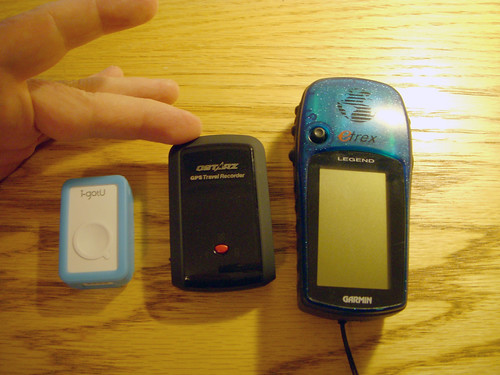
As can be seen in the photo above, the Qstarz (middle) is a good bit larger than the i-gotU, but still smaller than my Garmen eTrex. It’s still small enough to slip into a pocket, and it comes with a protective cover that has a belt loop.
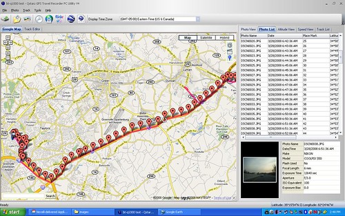
The Qstarz uses the MTK chipset, and boasts great accuracy and battery life. I haven’t been able to really test battery life, but accuracy seems to be excellent. As with my previous tests, I set up my camera in interval mode so that it would snap a picture every 30 seconds, turned on the Qstarz, and drove to work. I placed the GPS on the dash board so that it had a clear view of the skies. Unlike the i-gotU, the unit accurately tracked my drive, and more importantly, accurately placed the photos along the route. As you can see in the screen shot below, the images are evenly spaced out along the path.
The controls on the unit are very straightforward. There is a two-position slide switch to turn the unit on. The first position is Bluetooth only, if you only want to use the unit with a PDA or similar device. The second position turns on the logging/tracking system in addition to Bluetooth. That’s the setting you need for geotagging. On the top is a red button for saving placemarks. There are also very clear LEDs on top of the unit to indicate satellite lock, etc. One complaint Chip had, and that I have noticed, is that when the unit is slid into its protective sleeve, it had a tendency to slide the switch on the side. It’s best to double-check its switch position when sliding it in and out. The unit also comes with a USB cable, wall plug charger, and auto charger.
The software is very straightforward. Geotagging is a simple three-button process. Click one button to download the GPS track, click another to select either a folder of images or select single photos. The program automagically matches position data. As with any good geotagging program, there are time offsets and the ability to edit both the tracks and EXIF data. Once you have things the way you want, the third button writes the location data to the image files. It’s actually much simpler than Geosetter or any of the other tagging systems I’ve used. You can save the GPS track as a GPX file and export the information to Google Earth.
One of the appeals of the Qstarz was its supposed ability to maintain a satellite track even if its in your pocket. On my way back from a meeting in Spartanburg, I turned the unit on a put it in my pocket. I stopped to snap a couple of pictures, so as the one below:

This was one of the original Hardee’s locations, and at one time it still boasted the circular building architecture. It’s now a Thai restaurant. Regardless, I was able to accurately geotag its position even with the unit in my pocket. Over the next couple of days I tried several other shots with the Qstarz in my pocket, and all of them, without exception, were geotagged correctly. I was impressed.
So, in short, this is the device for which I’ve been searching. It performs beautifully, and is unobtrusive. I would highly recommend the Qstarz BT-Q1000.
[tags]geotagging, photography, GPS, Qstarz BT-Q1000[/tags]
I got one – works great! Thanks for the review. I’ve noticed on issue, when geotagging the jpg files, the exif data is missing the GPSVersionID tag, so things like picasa don’t read the GPS data. This must be down to v4 of the utility. Anyone else noticed this or found a fix?
This gps receiver is simple to use and satellite reception was always great, even during snowstorms, being indoors, or metro areas. But this unit is not cost-effective enough, the price is too high.
My friend told me that he just got another better unit, it’s Canmore GT-750 FL – similar spec but not too pricey. Also he never experienced anything that disappointed him w/ it’s performance of his Dell Axim X51. I plan to get this one shortly.