Houston and I had a day off in common, so it was time for one of our mid-winter photo treks. I really like exploring the area south of Abbeville, McCormick, and Edgefield. That part of the state is rather remote and rich in history, including our family history. Even though we’ve been down that way several times, I never seem to cover all of it, so it was ripe as another target.
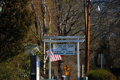
Our exploration group was larger than usual. In addition to the two of us, Houston’s wife, Lynda, was coming along, as was our sister Glynda. The plan was to meet Houston and Lynda Sunday morning in the parking lot of Calhoun Falls Pentecostal Holiness Church. From there we would head south and see what we would find. Our route would take us past paddling venues, ghost towns, fire towers, and several important genealogy spots. It had the makings of a perfect day.
As we started out the weight of family history hung heavy on us. There was our starting point, a church founded by my grandfather, and attended by many of my father’s siblings. The last times I’ve attended here were for funerals for aunts and uncles. Then there was the fact that this was the first trek we had made since Dad had died. Dad was the one who started us on this love of rambling, so we dedicated this trip to him before heading out.
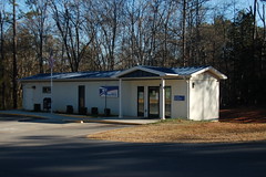
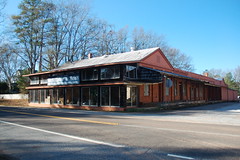
We drove through the little town of Calhoun Falls, looking for breakfast. Unfortunately, none was to be found. It being Sunday, everything seemed to be closed except the Hickory Point gas station. Lynda rejected that idea. We had hoped to find at least a couple of eateries. Calhoun Falls seems like a depressed area, like so many South Carolina towns that have lost their textile mill. With the construction of Richard Russell Lake, I’m sure they were counting on tourism dollars to revive the town. Alas, that didn’t seem to be the case on this early Sunday morning.
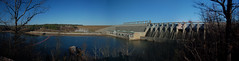
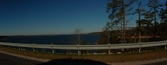
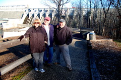
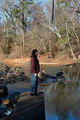
We continued south and decided to check out the Russell Dam Overlook. The three Taylor brothers have a camping/padding trip coming up in a couple of months, and we were looking for a good locations. Russell Lake looked like it had potential because there is no development along the shore.
It was a bit chilly out with a stiff breeze. We posed for a couple of shots, then continued on our way.
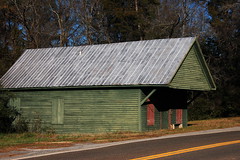
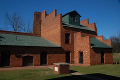
We wound our way through the county and crossed over from Abbeville into McCormick County. Our next stop was the Calhoun Mill area, a place Houston and I found on our previous trip to Mount Carmel. On that first trip we had started from Greenville and gotten distracted along the way. This time we were closer to our target earlier in the day, so we knew we would hit more of the county.
We only spent a few minutes at Calhoun Mill. The buildings seemed to be in the same condition we had found them on the previous trip. As tempting as it might have been, we did not jump the fence and explore the buildings.

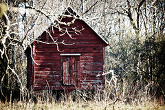
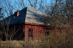
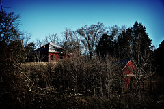
I’m beginning to wonder if this area might not qualify as a ghost town for inclusion in our book. This was a center of commerce, with a school, post office, and several other stores and other buildings. It appears on Robert Mills’ 1825 Atlas, whereas several of the surrounding towns such as Calhoun Falls and McCormick do not.
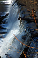
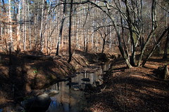
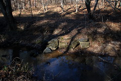
We crossed the Little River and continued to the dam just upstream from the mill. This is a picturesque area, and looks like it would be another good paddling venue. The river is wide above the dam, and looks like it would be good for kayaking.

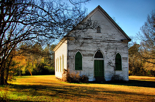
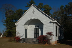
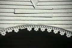
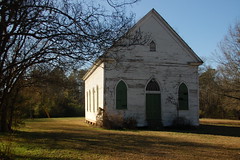
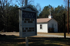
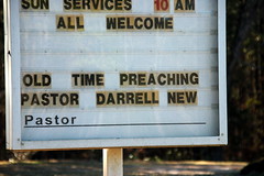
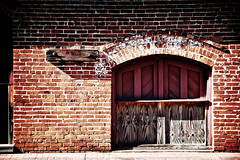
We turned back southwest and headed toward Mount Carmel. Our first stop was at the north end of town at the Mount Carmel ARP church. The lighting was excellent, so we took some shots of the filigree work over the arched entryway.
None of the stores were open in Mount Carmel, either. The little quick shop was closed, as was McAllister Furniture. We had to laugh because the trailer post office had a sign that read “Mount Carmel Main Post Office”, as if there were a smaller auxiliary office nearby.
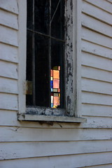
We spent also spent some time at the other end of town at the Mount Carmel Presbyterian Church. Both of these churches are no longer in use, sadly, so there were no worries about interrupting a Sunday service. We wanted to see the interior, and desperately tried to take photos through cracks in the shutters. Alas, we were only able to get external shots.


I had a couple of other potential ghost towns on our route. Someone had mentioned Willington. I had my doubts, since it was on the main highway, and those were proved true. Someone has started to revitalize the small town, which now boasts a cafe, museum, and book store.
I figured any place that has a Thai restaurant can’t really be called a ghost town.
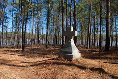
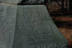
The next ghost town was a bit more elusive. The town of New Bordeaux was established as part of the Bounty Act of 1761, which encouraged township settlement as a deterrent to Indian attacks. I had several locations marked for the town. First, there was the stone monument marking the place of worship for the old Huguenot community. Then there was the community of Bordeaux, as indicated by the GNIS data. And finally, there were descriptions of the location of the town as being either being inundated by Clark Hill, or located within the Savannah Lakes subdivision. The one remaining structure from the New Bordeaux settlement, the Gillebeau House, has been moved to Hickory Knob State Park.
According to records, there were about 345 residents of the community and another 475 in the surrounding area. Even today French names dominate the area. These 475 seem to have been spread out over the entire area, so I wasn’t sure where to start.
I decided to find the stone monument first, and put the coordinates into my GPS. We took several dirt roads, include forest service roads and the Willington Academy Road. One road took us to a dead end. However, a bit of investigation lead us to believe that we were actually on an old road bed. A stack of stones and a bit of metal marked a bridge abutment for the old road bed. Unfortunately, there was nothing else there to indicate a settlement. We were close, but not in the right place.
We back-tracked, then decided to head toward McCormick. We actually passed through the community of Bordeaux, or at least, the one indicated by GNIS. It was located at an intersection with one large historic home and the Bordeaux Methodist Church. We found the church sign especially ironic.
We came upon a historical marker for New Bordeaux, as well as a sign pointing to the stone monument we were after. We turned down that road, aptly named the “Huguenot Parkway.” We were directed onto another dirt road that headed down toward the lake. On a point next to the lake we found the monument. If I were to mark the location of this “ghost town”, I guess this would be as good a place as any. I don’t think an area in the middle of a subdivision would count.
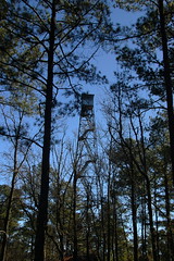
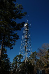
When we got back to the McCormick Highway I looked up, and right in front of us was a fire tower. This was the McCormick tower, and looked to be in pretty good shape. It was located right behind a 1960s vintage ranch house, which I suspect wasn’t the original keeper’s house. Houston said he would LOVE to have his own tower in his back yard. So would I. I guess you never outgrow tree houses.
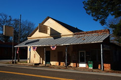
We finally reached the town of McCormick about lunch time. There were a couple of fast food places, but we were also after culinary adventure, which we certainly found.
As with Calhoun Falls, there were several promising cafes and bakeries. However, they were all closed. Finally we came around a corner and found the McCormick Drive-In open, and decided to risk it.
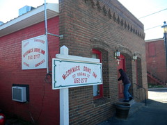
I’m not sure how this qualifies as a “drive-in.” There was no covered area to park and order. I guess it’s a drive-in only in the sense that you might be able to park in front of it, if you can find a space.
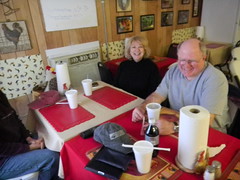
Finding a place to sit was also a challenge. There was one long table with six chairs, one smaller table for two, and a table for four that was occupied by two local police officers. We claimed the six-chair table and headed to the counter to order.
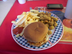
The menu had typical family-owned fast food items – hamburgers, hot dogs, sandwiches, and plates that could be constructed from said items. Lynda got a flounder plate, Glynda a burger, and Houston and I got the BBQ plates, mine with fries and okra. Yeah, I was living dangerously.

The place was tiny and covered with rooster decor. EVERYTHING had a rooster on it, from the plates to the art to the wallpaper itself. A small half-door separated the tiny dining area from the even tinier kitchen. You had to walk through the food prep area to get to the single restroom in the joint, neither of which was a site I really wanted to see before eating. The restroom itself was doubling as storage for pasta, tomato sauce and green tea. I was glad I hadn’t ordered spaghetti and decided to stick with a bottle Diet Coke.
The woman who took our orders sat behind the counter in a rolling office chair which she never left. I don’t think we saw her get out of it at all. She rolled it quickly from behind the counter to the kitchen at one point, so she could get around. I guess she just didn’t like standing or had some other reason for staying seated. As we ate she stared off into the distance. I snapped a quick photo and she turned, as if feeling part of her soul drain away.

We survived the meal, and it was time to head on. We took a quick turn through the little town, then stopped for a moment at the old Dorn Grist Mill, which has been redeveloped as an interpretive center. Of course, it wasn’t open on Sunday, either, so we just took some shots of the outside.
Saturday night before our trip I had been looking in Google Earth for geotagged photos of the area. I always do this for potential trek targets because I like to see what caught someone else’s eye. This time I really hit pay dirt. Not too far from McCormick someone had posted a monument to the Utz-Ouzts family and a cemetery close by. We descend from the Ouzts and Dorn families from this area on my mother’s side, so we knew we had to find this monument.
We headed east from McCormick along Highway 378. Just after crossing into Edgefield County we came upon another fire tower. The Liberty Hill tower also appeared to be in good shape. It looked like it was now being used as an antenna tower. We paused to take a photo.

Eventually we came to a five point intersection at McKendree Methodist Church. Across one of the side roads from the church was the Utz-Ouzts monument.
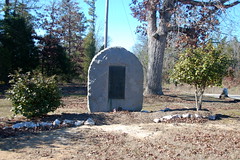
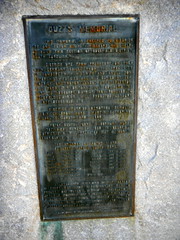
The monument describes how Dietrich Utz left Frankfort-am-Main with his wife and son, George Peter, and traveled to America aboard the Brittania. His wife died en route, and was buried at sea. They settled in this area in 1766, about the same time that the Taylors were settling in Laurens County. After settling in the area, the spelling of the last name changed to Ouzts. Dietrich Utz was my great-great-great-great-great grandfather.
Lynda wandered through the cemetery of McKendree Methodist and found lots of surnames associated with our family, including Ouzts, Dorn, Timmerman, and Harlan. While there were some old headstones, none dated back as old as the monument indicated.
This side road continued across from the church, and across Highway 378. On the other side of the highway we could see a sign pointing us toward the Utz-Ouzts cemetery. We had to check it out.
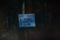
We continued down the side road for about a mile, then turned onto a dirt road. After another half mile we reached the cemetery.
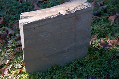
The area looked like it was being well-maintained. Trees had recently been trimmed and the grass was neat. The headstones looked ancient, and in some cases looked like little more than short stones marking the graves.
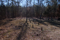
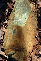
Apart from some “newer”, more elaborate stones, most appeared to be hand-etched. Some were of an unusual blue stone that didn’t look native to the area. We had no idea where these might have originated.
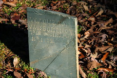
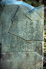
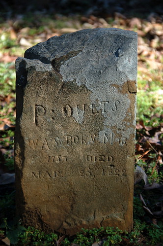
I finally found one of the stones I was after. I believe the “P. Ouzts” listed on this stone is my great-great-great-great grandfather. The dates are certainly correct, 1757-1829, according to the monument.
This was a major find for us, and capped off the day nicely. We left the cemetery and retraced our steps back through McCormick. As we crossed an arm of Clark Hill Reservoir we paused for one last shot. The water levels were very low, and an old bridge that crossed Long Cane Creek was now exposed – a reminder of what had once been here.

Here is an interactive map of our travels with major locations indicated…
View 1-15-2012 McCormick Exploration in a larger map
As usual, I couldn’t include all of the photos in this post. All of the photos from the trip can be seen in the slide show below:
Tom,
Enjoyed your photo trek. We spend a lot of time up in these areas of Little River, Long Cane Creek, Sumter National Forest, the state parks, and the unique area surrounding Savannah Lakes Village & Golf Clubs. The towns, waterways, and public lands in the area are great for exploring and wildlife viewing. I often take my sons out with me on these adventures, and it seems we learn something new each time we are out.
http://www.LittleRiverBlueway.org is great source of infomraiton/mapping of paddling routes, hiking biking trails, and historical sites. You can also find information about upcoming events in the region in the news room and blueway caldendar. Come back on a morning other than Sunday, and there are a number of unique stores in downtown McCormick for antiquing, an early 1900’s soda fountain at the drug store, traditional hardware store, artist shops at the McCormick Arts Council, and several restuarants.
Thanks again… Really enjoyed your photo tour of the area. Felt like I was traveling along with you!
All the Best!
Kirk
Thanks, Kirk. I knew that hitting these small towns on a Sunday would be problematic. I really want to get back down to the Willington bookstore and museum, as well as some of the shops in McCormick.
The Little River Blueways site is excellent! I wish I’d had these maps before setting out on our trip. I definitely want to do some of the paddle routes on both Little River and Long Cane Creek.
Your family history on your mother’s side is my history also since she was a sister to my dad. I enjoy these ramblings from afar. Thank you for sending it out for others to gain knowledge from.
Do you have any pictures of the house in NinetySix where our grandparents lived. I vividly recall going there as a child. We could share those stories sometime if you wish.
This was a great read. I had a good laugh at, “as if feeling part of her soul drain away.” LOL.
The family cemetery was a great find and I haven’t seen too many head stones made of that stone either. They looked like they were in good shape for their age.
Also, I was thrilled to see a photo of the exposed bridge crossing Long Cane Creek. When I was driving to Augusta a lot earlier this year, I passed this bridge every time and I always thought I should get a photo of it, but never did.
Great adventure!
Could the mystery stones be blue slate?
Possibly, and that thought had crossed my mind.
Thanks Tom… Yes, definately bring the kayak the next time you visit the Little River Blueway Adventure Area… Amazing scenery all of the paddling routes above huguenot parkway on Little River and Long Cane Creek are buffered by national forest land. The wildlife in these areas is abundant. Bald Eagles are seen on every paddling trip trip we take.
A return trip just to hit the Willington Book Store and the Willington Historical Center is worth your time. Back in the early 1800’s Willington and the area that is McCormick County today had a strong economy (cotton) and Willington Academy alumni were the leaders of our state and our young nation at the time. Dr. Moses Waddel was the head master, who later went on to turn around the University of Georgia. Even back in the 1800’s, the academy was known as the “School in the Woods.” Interesting correlation with the nature based recreation the Little River Blueway region offers to residents and visitors today.
I’m posting your McCormick County Photo Trek on our FB page… Hope you don’t mind.
Link up with us at http://www.facebook.com/LittleRiverBlueway
Tom – enjoyed reading about your travels. Hubby and I recently drove the Little River Blueway; loved those back roads. I regret not stopping to take pictures.
I, too, am descended from Peter Ouzts – the line of Henry Ouzts. Which is your line? One day – I want to find that cemetery also. Thanks for sharing.
Wow! Thanks for the history lesson! My Mom was an Ouzts, descendent of Guy. Very interesting!
Enjoyed your trek up 378. We obviously share some of the same relatives. Otherwise I would not be even looking at this website. My connection is Peter Ouzts – Henry Ouzts – Sarah Ouzts m. Wright Dorn. I’m a native of Saluda Co – Good Hope Section of county. Have in years passed when I made trips to my home, I would visit McKendree Church and look among the headstones for relatives. I was not even aware of the cemetery, just so close to McKendree when I was making my visits. We all share a lot of DNA. Don’t get to visit any more, so do enjoy the little research I can do on the internet. What fun! Happy traveling, relative (coz?).
I really enjoyed the pictures lived in area many years. My grandmother was an ouzts from edgefield.
I just stumbled upon your blog today and really enjoyed reading about your search for the Ouzts cemetery and accompanying pictures. I grew up in Elberton, Georgia, just across the state line from Calhoun Falls, but lived all over the country before coming back to Elberton in 2009. I am descended from 2 of Peter Ouzts’ sons, Martin and Jacob. I have always wanted to go search for that cemetery, and I may be able to use your blog directions to help me when I finally get around to it. I find that trying to locate places in South Carolina will get me lost more often than not. When I go to Edgefield for a funeral or birthday party from time to time, I always end up going a different way, not intentionally but just from lack of map skills or poor sense of direction. I always get there, though, like some slightly tipsy homing pigeon. Thanks for marking (and photographing) the sometimes obscure path.
So – it’s been 6 years since I read your Trek and posted that I want to go to the McKendree Cemetery. Hubby and I were near there yesterday – looking for the Ansel Talbert Cemetery off Hwy 278. Didn’t find it but werre near. My maiden name is Talbert. Both my parents were from Edgefield County – with some more distant relatives in McCormick County. I have Ouzts and Dorn in my Smith line also. A number of relatives on here.