Skip to content

Random Connections

A collection of photography and exploration focusing on Upstate South Carolina and beyond.

  • Home
  • About Us
  • Photos
  • Resources
  • Other Voices
  • Post Archives
  • Home
  • Geocaching and Maps
  • Google Maps Gets Even Easier

Google Maps Gets Even Easier

Posted on August 23, 2007 By Tom No Comments on Google Maps Gets Even Easier
Geocaching and Maps, Internet

Google was on a roll yesterday with new product releases. Google Sky took the limelight, but there was another little change that seemed somewhat inconsequential, but has far-reaching implications for the wider use of Google Maps in applications all over the web. If you go to Google Maps and enter any address, you will see the following in the upper right corner of the map…

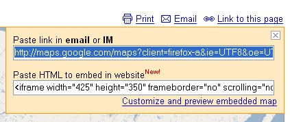
Clicking on the “Link to this page” link brings up a dialog box with two boxes of information. The first is a direct link to the map. The second is a bit of HTML which will let you embed the map into various web pages.

Prior to this little innovation, users could either link directly to the Google Maps page, or they could go through the process of getting a Google Maps API, setting up the javascript code, then hoping that it all worked in their particular map. Embedding maps into Blogger and other hosted sites was difficult, at best. With this new application, it’s a snap. For example, if I wanted to show the location of the restaurant where I had dinner last night, it’s not problem. I find it in maps and use this new embed feature.


View Larger Map

The only problem is that sometimes the iframe HTML tag isn’t interpreted correctly within the WordPress framework. Other than that, it’s a snap.

I can actually embed multiple maps into posts. Here I’m going back to one of my earlier projects – the Ghosts of Upstate South Carolina. I have that as a KML file here on that site. All I have to do is reference that KML file in Google Maps, then copy and paste the code…


View Larger Map

Now that I can link geocoded RSS feeds with Yahoo Pipes and send the output to a KML file, I can use this data as an embedded map, too. Below is a mashup of the feed from RandomConnections along with a feed from my Flickr account. Any recent post or photo that has been geotagged should show up on the map.


View Larger Map

The only thing that bothers me about a map such as the one above is the roundabout way in which the data gets there. First, the data from this website is parsed through Yahoo Pipes and rendered as a KML file. Next, Google Maps creates a display based on that KML file. Finally, the Google Map is displayed here, right back where it all started. I can see the potential for problems with recursive loops. In fact, the map above gave me problems, and may still have some display errors.

Regardless, this is a cool innovation, and one I’m sure I’ll use lots more. I’ve already suggested this as a solution to our RiverVenture problem. It will be fun to see how SCETV uses this new feature.

Post navigation

❮ Previous Post: The pipes, the pipes are calling
Next Post: La Superior Taqueria ❯

Leave a Reply Cancel reply

Your email address will not be published. Required fields are marked *

This site uses Akismet to reduce spam. Learn how your comment data is processed.

Categories

  • EdTech (200)
  • Entertainment (202)
  • Family (121)
  • Gear (115)
  • General Technology (99)
  • Geocaching and Maps (208)
  • History and Genealogy (266)
  • Internet (144)
  • Local (451)
  • Miscellaneous (550)
  • Music (196)
  • Paddling (248)
  • Photography (779)
  • Podcast (6)
  • Rambling (227)
  • Rants (161)
  • Recipes (34)
  • Religion (48)
  • Restaurants (165)
  • Science (48)
  • Things Overheard (29)
  • Travel (411)
  • Uncategorized (129)
  • Washington Sabbatical (113)
  • Weirdness (60)

Recent Posts

  • In Search of the Road Builder
  • The Phoenix Riots and Dr. Benjamin Mays – An MLK Day Ramble
  • An Obsession with Steak Knives
  • An Epiphany on Patriotism
  • Kayaking Bates Old River and Running Creek

Recent Comments

  • Walter Kokoszka on Mysterious Mayucha and The Wolf Pit
  • Elizabeth on The Temple of Health: Ground-Truthing in Antreville
  • The Bay Area Basketball Fan’s Guide to March Madness on FU All the Time!
  • Why You Should Root For This March Madness Underdog on FU All the Time!
  • Gregory Davis on Ghost Towns of the Pee Dee – Part 2, Centenary

Tags

blogging cemetery Christmas Columbia Edisto River edtech Entertainment family Flickr Florida Furman Furman University gear Georgia geotagging Ghost Town Ghost Towns Google Earth Google Maps GPS Greenville Greenville Chorale history Instructional Technology kayaking Lake Jocassee LCU Lowcountry Unfiltered maps Music North Carolina Paddling Photography rambling restaurant Restaurants review singing social networking South Carolina time-lapse Travel video Washington Washington State
March 2023
S M T W T F S
 1234
567891011
12131415161718
19202122232425
262728293031  
« Jan    

Copyright © 2023 Random Connections.

Theme: Oceanly by ScriptsTown