Skip to content

Random Connections

A collection of photography and exploration focusing on Upstate South Carolina and beyond.

  • Home
  • About Us
  • Photos
  • Resources
  • Other Voices
  • Post Archives
  • Podcast
  • Home
  • Geocaching and Maps
  • Google Earth and Google Plus

Google Earth and Google Plus

Posted on February 15, 2012 By Tom 1 Comment on Google Earth and Google Plus
Geocaching and Maps, Internet

I hadn’t realized how far behind the times I’ve been with Google Earth until I ready on Frank Taylor’s blog that there is an update out for a version beyond the one I’m using. That means I’m two versions behind.

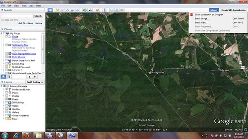
Version 6.2 makes some changes to the overall appearance of the map, with a “pretty Earth” effect. At wider zoom ranges, the surface of the map appears uniform, unlike older versions that showed rectangular swaths that mirrored imagery acquisition and satellite routes. As you zoom into the surface, more details emerge.

While this is all looks nice, the more functional improvement is the addition of enhanced sharing features in Google Earth. You can log directly into your Google Plus account, which opens lots of options for sharing GE data.  In the top right part of the screen you can now find a Share Button and a button to log into your G+ account.

GE Google Plus

From the drop-down menu you have five options:

  1. Share a screenshot in Google Plus
  2. E-mail an image
  3. E-mail the current view
  4. E-mail a placemark (one must be active to use this function)
  5. Share with the Google Earth Community

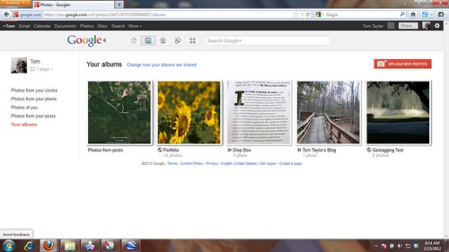
You can still save screenshots as JPG files.  That’s what I had been doing, uploading the images to Flickr when I wanted to share on this blog.  Now I’ll just pop them into G+ and link from there.

GE Google Plus

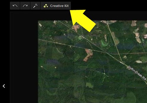
Google has acquired the online image editor Picnic. That product is being phased out, but the service itself is being incorporated into other Google products. If you open your Google Earth screenshot (or any other image, for that matter) in the Lightbox view, you will see a link to the “Creative Kit”, which is what Picnic has become.

GE Google Plus

Unfortunately, not all of Picnic has been ported over to the Creative Kit. I couldn’t find any of the shapes, arrows, and lines that made image mark-up a breeze in Picnic, so I had to draw lines manually (and rather squiggly, I might add.)

GE Google Plus

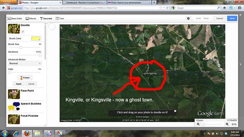
Still, it’s a nice, quick way to share Google Earth data, and I’m looking forward to doing more with it.

Tags: Google Earth Google Plus maps

Post navigation

❮ Previous Post: Kingville, Kingsville
Next Post: Spam Injection ❯

One thought on “Google Earth and Google Plus”

  1. Mark says:
    February 15, 2012 at 8:46 pm

    Google’s Earth’s “Help > Check for updates online” has never worked for me. I aways have to manually check from time to time. Thanks for the heads up.

    Reply

Leave a Reply to Mark Cancel reply

Your email address will not be published. Required fields are marked *

This site uses Akismet to reduce spam. Learn how your comment data is processed.

Categories

  • EdTech (197)
  • Entertainment (202)
  • Family (123)
  • Gear (114)
  • General Technology (98)
  • Geocaching and Maps (208)
  • History and Genealogy (275)
  • Internet (142)
  • Local (459)
  • Miscellaneous (560)
  • Music (202)
  • Paddling (268)
  • Photography (781)
  • Podcast (19)
  • Rambling (233)
  • Rants (162)
  • Recipes (37)
  • Religion (48)
  • Restaurants (165)
  • Science (48)
  • Things Overheard (29)
  • Travel (413)
  • Uncategorized (143)
  • Washington Sabbatical (113)
  • Weirdness (61)

Recent Posts

  • Helene One Year Later
  • Once Again, Up the Long Nose
  • Upstate Renaissance Faire
  • Exploring Lake Summit
  • The End of Days

Recent Comments

  • Gay on In Search of the Road Builder
  • Virgil Howell on The Ghost Towns of Lake Marion
  • Virgil Howell on Return to Ferguson
  • Mary Copeland Myers on Renno and Stomp Springs
  • Virginia Pepper on Helene One Year Later

Tags

blogging cemetery Christmas Columbia Edisto River edtech Entertainment family Flickr Florida Furman Furman University gear Georgia geotagging Ghost Town Ghost Towns Google Earth Google Maps GPS Greenville Greenville Chorale history Instructional Technology kayaking Lake Jocassee LCU Lowcountry Unfiltered maps Music North Carolina Paddling Photography rambling restaurant Restaurants review singing social networking South Carolina time-lapse Travel video Washington Washington State
October 2025
S M T W T F S
 1234
567891011
12131415161718
19202122232425
262728293031  
« Sep    

Copyright © 2025 Random Connections.

Theme: Oceanly by ScriptsTown