Skip to content

Random Connections

A collection of photography and exploration focusing on Upstate South Carolina and beyond.

  • Home
  • About Us
  • Photos
  • Resources
  • Other Voices
  • Post Archives
  • Podcast
  • Home
  • Internet
  • Page 3

Category: Internet

Google Earth and Google Plus

Posted on February 15, 2012 By Tom 1 Comment on Google Earth and Google Plus
Geocaching and Maps, Internet

I hadn’t realized how far behind the times I’ve been with Google Earth until I ready on Frank Taylor’s blog that there is an update out for a version beyond the one I’m using. That means I’m two versions behind. Version 6.2 makes some changes to the overall appearance of the map, with a “pretty … Read More “Google Earth and Google Plus” »

Audio Sharing with Chirbit

Posted on January 20, 2012 By Tom 3 Comments on Audio Sharing with Chirbit
Internet, Music

MWSnap024 2012-01-20, 08_11_44

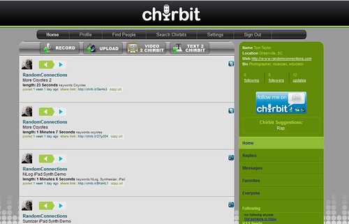
Some time back I posted a wish list for audio file sharing. I was looking for something analogous to YouTube, but for audio only. I found two services, Audioboo and SoundCloud, that seem to work well, and I’ve been using those. However, a third one has come onto the scene. Chirbit is about audio hosting system, and it seems to meet most of my wish list items.

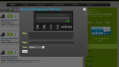
Chirbit as many of the same features as Audioboo and Soundcloud. It appears to be set up more on the Audioboo model, which allows user an unlimited number of files, but restricts the length of of those files. Accounts are free, but there is an upgrade to a paid version which allows longer files. Here’s an example using my traditional test file, my reading of Edgar Allen Poe’s Annabel Lee…


Check this out on Chirbit

As with the other services, you can upload various audio files, or you can record directly into the service from your computer’s microphone. Chirbit offers two other options. First, you can strip the audio from YouTube videos to upload to the service. You input the URL for the video, and it uploads that to Chirbit.

MWSnap025 2012-01-20, 08_12_00

Read More “Audio Sharing with Chirbit” »

Google Image Search

Posted on September 28, 2011 By Tom 2 Comments on Google Image Search
Internet, Photography

Sometime over the summer, and apparently without enough fanfare for it to ping my sonar, Google announced a new “search by image” service. The idea is that you can either upload an image file, or post a link to an online image, an Google will go out and search either for matches to that image, images that are “visually similar”, or if the image can be identified, links to information about that image. I finally got a few spare minutes to take a look, so I decided to try a few experiments.

Only recently did this new service come to my attention. My fellow Flickr photographer Eric Morris, aka The Rested Traveler, had posted a link on his Facebook page to a blog post where the writer used the image search to see if his images had been used without his permission. Having been the victim of photo theft before, I thought this was a good starting point.

Read More “Google Image Search” »

Where were you born?

Posted on July 11, 2011 By Tom No Comments on Where were you born?
EdTech, Geocaching and Maps, Internet

Dear Twitterites, Facebook Friends, Google Plussers, and RandomConnections Readers: I need your help with a project.  This summer I’m doing several workshops for SCETV on Google products, including Google Earth and Google Docs. I’m hoping to include some information on Google Fusion Tables as part of the workshop, and in order to do that I … Read More “Where were you born?” »

GNIS Dilemma

Posted on June 6, 2011 By Tom No Comments on GNIS Dilemma
Geocaching and Maps, Internet

The Geographic Names Information System(GNIS) is one of the greatest boons to those of us who love maps. It’s an extensive database of place names created by the US Geological Survey, and includes cities, towns, communities, crossroads, schools, churches, mountains, rivers, etc,. etc. Basically, any place in the US that has a name is in the database. The database includes coordinates, county, and other basic information about that location.

I’ve used and referenced the GNIS data on this blog many times. The raw data is freely available for download, and I have downloaded just the South Carolina data to create my South Carolina Place Names application. If you’ve ever used a GPS or looked up a location on an online mapping system, you’ve encountered GNIS data. Unfortunately, some companies use this freely available data to flood the web with crappy websites that pollute search results and interfere with the ability to do any meaningful online research about an area.

Here an example…

Yesterday my sister Glynda and I drove through the communities of Stomp Springs and Renno on our way back from visiting our parents in Prosperity. It’s a historical area, and we snapped a few photos and looked at the ruins of the old towns. When I got home I wanted to find more information about the area, so I did a quick Google search for Renno, SC. Here’s the first page of results. You’ll want to click to enlarge…

Renno1.png by RndConnections on Aviary

Most of the pages are for “hometown locators” and various real estate companies. There were even multiple websites for various cable companies. This goes on for multiple search pages – basically a spamming of the Internet based on the GNIS data.

Read More “GNIS Dilemma” »

Greenville Historical Aerial Imagery

Posted on April 5, 2011 By Tom 3 Comments on Greenville Historical Aerial Imagery
History and Genealogy, Internet, Local

Downtown Sanford 1920

Sometime last week the Greenville Cageliner had an article about a new website from the Greenville County GIS Office (http://gis.greenvillesc.gov/historicalimagery/). The website features historical aerial photography imagery as a map, similar to Google Earth. Images are available for 1955, 1965, 1979, 1989, 1997, and 2009, and cover the downtown area, along with a bit of the county. Also included is the Sanford Insurance Map of the city from 1920.

I could spend a HUGE amount of time exploring the site. Looking at how the city has changed over the decades has been fascinating, and somewhat depressing. The patterns of urban sprawl are quite clear at a distance, and it can be sad to look back on landmarks that are no longer there. On the other hand, there have been some marked improvements in areas such as along the banks of the Reedy River, and these images show that very clearly.

I started with the area around the old Furman campus. I had never really understood the location of the old bell tower in relation to the rest of the campus, but this imagery makes it very clear. (Click on the images for a larger view.)

Old Furman Campus 1955

Read More “Greenville Historical Aerial Imagery” »

Research Tips with a Camera

Posted on March 7, 2011 By Tom 6 Comments on Research Tips with a Camera
EdTech, General Technology, Internet

As I was doing the research for my post on South Carolina’s Tricentennial, one point was driven home – you just can’t find everything you need on the Internet. That’s a lesson our students often forget. Sometimes you just have to crack open a book or make a trip to the local library in order to get the information you need.

I have, however, found a couple of tricks to make library research much easier, especially if you’re working with reference materials and other items that have limited circulation, or that can’t be removed from the library. I’ve found these techniques especially helpful in places like the South Carolina Room of the Greenville County Library, where the items are often one of a kind, and need to be protected.

I always have an old-fashioned pencil and paper for taking notes, but my research tool of choice lately has been my trusty Nikon S70 point and shoot camera. Today’s cameras have such high resolution and memory is so cheap that it’s just as easy to snap a picture of a page in a book to review later. You can zoom into the photo to read the text clearly, and it saves a ton of money on photocopying. You can also snap photos of images and illustrations, as well as bibliographical information for proper citation later.

Read More “Research Tips with a Camera” »

Geotagging “Threat”

Posted on March 4, 2011 By Tom No Comments on Geotagging “Threat”
Geocaching and Maps, Internet, Photography

Just when you thought it might be safe to let the kids out of the house, the news media comes up with even more scary stuff that you didn’t know about. This time geotagged photographs are the culprit. Two separate news outlets – MSNBC and ABC, have aired segments on the dangers of posting geotagged … Read More “Geotagging “Threat”” »

Not Quite Normal

Posted on March 3, 2011 By Tom No Comments on Not Quite Normal
EdTech, Internet

Some time ago I had a teacher ask me about Xtranormal as a possibility for digital storytelling. I took a brief look at it, and it appeared fairly simple and easy to use. You type in some text, and animated characters act and read what you typed in a mechanical voice. It seemed fairly simplistic, … Read More “Not Quite Normal” »

Fun with Anaglyphs – Part 4

Posted on February 23, 2011 By Tom No Comments on Fun with Anaglyphs – Part 4
General Technology, Internet, Photography

anaglyph still life

In the previous parts of this series I looked at ways of creating anaglyphs with Photoshop, both from old stereoscopic images and from a set of two images shot with a hand held camera. But what if you’ve already got a photograph and want to “fake” a 3D image? Well, I think I’ve worked out a method of doing that, too.

So far I haven’t found any tutorials online for creating fake anaglyphs in Photoshop. I did find Jim Long, who has done an excellent job of converting 2D images into 3D cyan-red anaglyphs. Jim as quite the gallery not just photographs, but also of classical art rendered both as stereoscopic images and as anaglyphs. Here’s his version of Da Vinci’s Mona Lisa:

I don’t know what process Jim is using, but he manages to maintain color on the images very well. He also has a link to a supplier of 3D glasses with one of the most extensive inventories I’ve seen.

Read More “Fun with Anaglyphs – Part 4” »

Posts pagination

Previous 1 2 3 4 … 15 Next

Categories

  • EdTech (197)
  • Entertainment (202)
  • Family (123)
  • Gear (114)
  • General Technology (98)
  • Geocaching and Maps (208)
  • History and Genealogy (275)
  • Internet (142)
  • Local (459)
  • Miscellaneous (560)
  • Music (202)
  • Paddling (268)
  • Photography (781)
  • Podcast (19)
  • Rambling (233)
  • Rants (162)
  • Recipes (37)
  • Religion (48)
  • Restaurants (165)
  • Science (48)
  • Things Overheard (29)
  • Travel (413)
  • Uncategorized (143)
  • Washington Sabbatical (113)
  • Weirdness (61)

Recent Posts

  • Helene One Year Later
  • Once Again, Up the Long Nose
  • Upstate Renaissance Faire
  • Exploring Lake Summit
  • The End of Days

Recent Comments

  • Gay on In Search of the Road Builder
  • Virgil Howell on The Ghost Towns of Lake Marion
  • Virgil Howell on Return to Ferguson
  • Mary Copeland Myers on Renno and Stomp Springs
  • Virginia Pepper on Helene One Year Later

Tags

blogging cemetery Christmas Columbia Edisto River edtech Entertainment family Flickr Florida Furman Furman University gear Georgia geotagging Ghost Town Ghost Towns Google Earth Google Maps GPS Greenville Greenville Chorale history Instructional Technology kayaking Lake Jocassee LCU Lowcountry Unfiltered maps Music North Carolina Paddling Photography rambling restaurant Restaurants review singing social networking South Carolina time-lapse Travel video Washington Washington State
October 2025
S M T W T F S
 1234
567891011
12131415161718
19202122232425
262728293031  
« Sep    

Copyright © 2025 Random Connections.

Theme: Oceanly by ScriptsTown