Laura had a quick business trip to Chicago, so Glynda and I decided to get out and see the countryside. I had spotted an advertisement for the Oconee Bale Trail, a series of decorated hay bales through that county, and it looked like as good an excuse as anything to get out and about.
Glynda hadn’t been with my on one of my photo rambles before. As with most of my family, she loves photography, too. She has also inherited our parents love of exploring backroads. While growing up, instead of calling her by her name Glynda Jo, my father called her “Glynda Go.” She had just finished her last day at the Boys Home of the South on Friday, so this was going to be a celebratory get-away.
We started our day’s outing with lunch at Cateran Lodge. This is a hole-in-the-wall buffett restaurant on Wade Hampton. They now have a new sign that draws more attention, but for most of its existence it’s been a place easy to overlook. The place was already filling up with folks that get out of church before noon, so we took our place in line.
The cook at Cateran has masterd the art of combining the staples – flour, milk, water, salt, and sugar. We had breaded and fried okra, chicken, and catfish. Each one was a little different, and appropriate for the dish. All the flavors were wonderful. Throw a little more sugar and some peaches into the staple mixture, and you had a delicious peach cobbler.
The place was starting to fill up, and we had places to go, so we headed on our way.
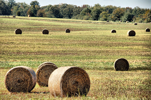
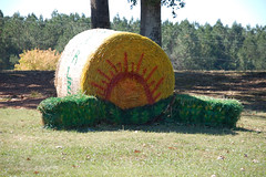
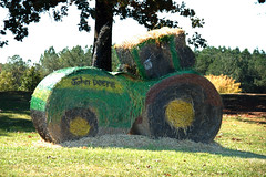
The Oconee Bale Trail has a nice Google Map with locations and links to photos of the decorated bales. But, of course, I forgot to print any of that out or download to my GPS. I remembered that the first bale was at the South Carolina Welcome Center on I-85, so we headed in that direction. Miles of interstate were uninteresting, though. I knew that most of the bales were around Westminster, so I took the Highway 24 exit and headed in that direction.
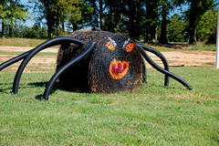
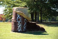
After passing many fields of undecorated bales, we eventually came to the town of Townville – a redundant name if ever I heard one. There we spotted our first bale – a spider.
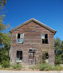
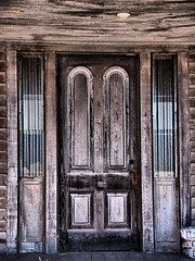
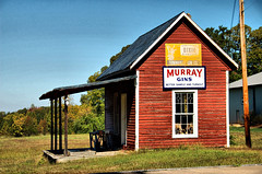
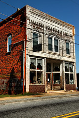
Townville turned out to have lots of interesting building. There were several old farm houses, and couple of abandoned stores, and some other places with interesting architecture.
From Townville we headed north, keeping our eyes open for more bales. We zig-zagged across the area, taking a dip down to Fairplay before heading north again. The scenery was quite nice, and we were enjoying the ride, but our bale trail seemed to have grown cold. It wasn’t until we got to the town of Westminster that we hit pay dirt. Here’s just a sampling of the ones we found around town…
In the same newspaper where I found the ad for the Bale Trail, I had also seen that Walhalla was holding its Oktoberfest celebration this weekend. We decided to bail on the bales and head in that direction.
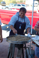
When we got to Walhalla there were several booths set up along the street, so we parked and started walking. There were just a few crafts, and not much of anything else. The smell of home made tacos and barbecue were overpowering. One booth had bratwurst and saurkraut, but since we just had a large lunch, we were only tempted. Even though it was probably a sacrilege, we opted for a couple of small tacos over the German food. These were a wonderful little snack, and we washed them down with a couple of cold drinks.
While eating, I saw a sign that said that the actual Oktoberfest was in a park about a mile away. We turned down that road and instantly regretted it. The traffic was stop-n-go, and the place was a zoo. When we finally got to the park where we could look in, we decided that parking would be a nightmare, and we really didn’t want to deal with crowds. I found a route around the mess, and soon we were headed north again, this time toward Stumphouse Tunnel and Isaqueena Falls.
I guess with it being a pretty afternoon, with gas prices a bit lower, and with the large festival in town, everyone was out enjoying the day. The parking areas for the falls and tunnel were crowded, but we were able to find a spot. We first went to the falls, and were disappointed. The drought has really diminished the amount of water coming over the falls. I tried to take a couple of longer exposure shots, but so many people were walking on the wooden observation deck that camera shake ruined my shots. Oh well.
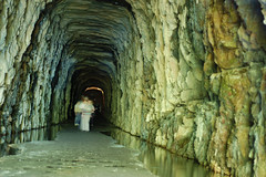
We drove on around to the tunnel to find it just as crowded. I was only able to find one working flashlight in the car (poor planning on my part), but we decided to stay close together and brave it anyway. I also carried my tripod and camera with my fast 50mm f/1.8 lens to try to get some long exposure shots from inside the tunnel.
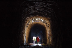
The first part of the tunnel was easy to navigate, even without a flashlight. As we went deeper, Glynda was having a harder time seeing, so I let her take the flashlight. When we got to the central ventilation shaft and the wall that separates the front of the tunnel from the rear, Glynda decided she didn’t want to go any further. I stepped to the other side of the wall and tried to take some pictures of the back of the tunnel. Surprisingly, some of the shots turned out, even with it as dark as it was.

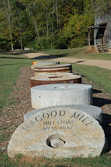
We made our way back out and to the car, then retraced our route back through Walhalla (avoiding the festival) and towards Highway 11. The afternoon was quickly escaping, so we drove on along the scenic road without stopping. When we got to the intersection with Highway 178, Glynda said that she had never visited Hagood Mill, so we made a brief detour in that direction.
When we got to the mill the visitor’s center and store were closed, but the grounds were open, so we wandered around. For the first time that I could remember, the petroglyphs were uncovered, and I could see the ancient stone carvings. We took a few photos in the angled afternoon light, then headed on our way.
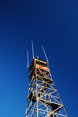
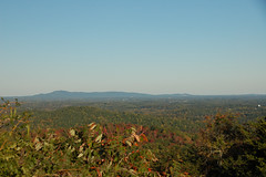
From the town of Pickens I had one more surprise stop. Glynda had also never been to the top of Glassy Mountain. We road up that way and enjoyed the view. I wished I could climb the steps to the old fire tower for an even better view, but, alas.
Not it was REALLY getting late. We had planned to cook for dinner, but instead opted for pizza out. Then it was time to head home and review the photos and videos we had taken. It was a good trip, and a good day.
Sounds like a cool trip. If you ever want a nice longer hike, take the Yellow Branch Falls trail (the parking area is on the left right about where Stumphouse Tunnel is on the right – maybe a little further back toward Walhaulla). The falls are beuatiful with a trickle or a torrent coming over them due to the fancy ledging. Also, Oconee Station is just off 11 on the way east from West Union. Nice falls there, plus the old blockhouse and some other stuff.
Thanks Tom. I was wondering who was going to take up the care-giver role when Glynda retired and had all that time on her hands. The whole family is counting on you.
great photos as usual. The trip sounds like an interesting day.
Y’awl notice on that first pic of hay bales in the field that he gets a pointalist type effect on the bales near us and even on the field itself. Most hay bale pix I’ve seen are really quite boring, but this one has that Seurat style that is rather cool.