Skip to content

Random Connections

A collection of photography and exploration focusing on Upstate South Carolina and beyond.

  • Home
  • About Us
  • Photos
  • Resources
  • Other Voices
  • Post Archives
  • Home
  • 2010
  • August
  • Page 2

Month: August 2010

Kayaking around Burrows Bay

Posted on August 5, 2010 By Tom 1 Comment on Kayaking around Burrows Bay
Paddling, Travel

Monday, August 2, 2010

One thing I love about this is the abundance of paddling opportunities. There are flatwater lakes, swift moving rivers, and challenging open water courses. I never get to do as much kayaking as I would like when I’m up here, so this time I decided to make sure I got to paddle at least a little bit. I booked a five-hour tour with Anacortes Kayak Tours before we left South Carolina.

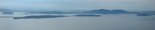
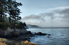
I set out early, planning to catch breakfast in one of my favorite joints in Anacortes before starting the tour. The bay between Samish and Fidalgo Islands was completely fogged in, but it looked like skies would be clearing. When I drove onto Fidalgo, the fog really set in. I found my way to my restaurant and had a fantastic breakfast while also putting out fires at work over the phone. So much for vacation.

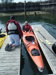
I headed on over to the kayak place. I had been another another tour around Hat Island several years ago, but it turns out that it was a different group. This place not only had kayak tours, but also offered whale watching tours.

I was early, and got my instructions to meet the rest of the group on the other side of Fidalgo. Since I had some time, I stopped by Washington Park, which is just past the Anacortes Ferry Terminal. This early the road around the park was closed to auto traffic, so I walked around and took a few shots.

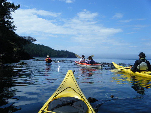
Pretty soon it was time to meet my group, so I headed to the Skyline Marina on Burrows Bay. In addition to myself and the guide, Ken, there were three others – Robbie from Tasmania, and sisters Sue and Carolyn. Robbie and I got single 17 foot Necky Looksha sea kayaks, and the two sisters got a tandem kayak. All of us were experienced kayakers, so Ken gave us some obligatory brief instructions, and we set out across the foggy water.

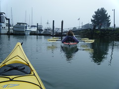
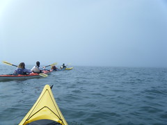
Our route would take us out around Burrows Island, with a stop at the lighthouse there. We would paddle on around Allan Island, then out to Williamson Rocks if we had time.

Read More “Kayaking around Burrows Bay” »

Upriver on the Skagit

Posted on August 5, 2010 By Tom No Comments on Upriver on the Skagit
Travel

Diablo Lake Panorama

NOTE: Just catching up with blogging after traveling around the islands. Things are a bit post-dated right now.

Sunday, August 1, 2010

Yesterday we followed the Skagit River through Mount Vernon and out to its confluence with the bay. Today we decided to head the opposite direction and follow the river upstream. Our route would takes up into the North Cascades National Park.

Old Skagit Railroad Trestle

We started on the Skagit River Road along the south side of the river, away from the more crowded Highway 20. The road twists through farms, runs through large stands of trees, and crosses many tributary streams. The last time we were up this way we found several access points that let us get down to the river for a better view. This time we couldn’t find the same access points, so we kept driving.

Near the town of Concrete we crossed the river and picked up Highway 20. The road crossed the Baker River, where we found a nice dirt road leading down to where The Baker and Skagit Meet.

Read More “Upriver on the Skagit” »

Skagit Ideal

Posted on August 1, 2010 By Tom No Comments on Skagit Ideal
Travel

Samish Island View

You see those mountains out there? They aren’t just mountains, those are islands!

So said my soon-too-be father-in-law, Jim Wright, as we drove across The Flats for my first visit to Samish Island in 1988. The reclaimed farmland that connected the mainland to the island created the illusion that we weren’t close to water at all. It wasn’t until we gained a bit of elevation that I saw that we were, in fact, surrounded by it.

Samish Island Panorama from Chuckanut

From that moment on, I was hooked. There was so much to see and do, and it was all so different from where I lived. Over the years, and with subsequent visits I’ve built up an ideal of life in Skagit Valley County. It’s an ideal of a slower pace of life, filled with cool weather, incredible scenery, wonderful coffee and fresh baked goods, produce from the local farms, and fantastic seafood. Each quaint little town is filled with curious characters and Victorian architecture. Travel up the Skagit River, and you enter the wilds of the Pacific Northwest, with soaring trees and volcanic mountains and lakes filled with glacial waters. Head two hours north or south, and you have the cultural vibrancy of Seattle or Vancouver. If I were to move from South Carolina, I think this would be where I’d want to settle.

Skagit Barn

Read More “Skagit Ideal” »

Posts navigation

Previous 1 2

Categories

  • EdTech (200)
  • Entertainment (201)
  • Family (120)
  • Gear (115)
  • General Technology (99)
  • Geocaching and Maps (208)
  • History and Genealogy (260)
  • Internet (144)
  • Local (449)
  • Miscellaneous (544)
  • Music (194)
  • Paddling (245)
  • Photography (779)
  • Podcast (6)
  • Rambling (226)
  • Rants (160)
  • Recipes (34)
  • Religion (48)
  • Restaurants (165)
  • Science (48)
  • Things Overheard (29)
  • Travel (410)
  • Uncategorized (129)
  • Washington Sabbatical (113)
  • Weirdness (60)

Recent Posts

  • Wilkinsville and a Mystery Church
  • A Farewell to the Greenville Chorale
  • Edisto River from Good Hope to Sullivan’s Landing
  • Paddling Lake Monticello
  • The Remnants of the City

Recent Comments

  • Tim Cathcart on Wilkinsville and a Mystery Church
  • Lana on Visiting Camp Asylum
  • Tom on Wilkinsville and a Mystery Church
  • Gary Anderson on Wilkinsville and a Mystery Church
  • Kris on Mystery Cemetery

Tags

blogging cemetery Christmas Columbia Edisto River edtech Entertainment family Flickr Florida Furman Furman University gear Georgia geotagging Ghost Town Ghost Towns Google Earth Google Maps GPS Greenville Greenville Chorale history Instructional Technology kayaking Lake Jocassee LCU Lowcountry Unfiltered maps Music North Carolina Paddling Photography rambling restaurant Restaurants review singing social networking South Carolina time-lapse Travel video Washington Washington State
August 2010
S M T W T F S
1234567
891011121314
15161718192021
22232425262728
293031  
« Jul   Sep »

Copyright © 2022 Random Connections.

Theme: Oceanly by ScriptsTown