NOTE: Just catching up with blogging after traveling around the islands. Things are a bit post-dated right now.
Sunday, August 1, 2010
Yesterday we followed the Skagit River through Mount Vernon and out to its confluence with the bay. Today we decided to head the opposite direction and follow the river upstream. Our route would takes up into the North Cascades National Park.

We started on the Skagit River Road along the south side of the river, away from the more crowded Highway 20. The road twists through farms, runs through large stands of trees, and crosses many tributary streams. The last time we were up this way we found several access points that let us get down to the river for a better view. This time we couldn’t find the same access points, so we kept driving.
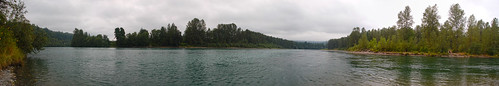
Near the town of Concrete we crossed the river and picked up Highway 20. The road crossed the Baker River, where we found a nice dirt road leading down to where The Baker and Skagit Meet.
We watched several large fish jumping and deciding which river to choose. Even though salmon season had just started, there weren’t many fishermen out on the river with us. Laura and her mom collected several smooth river stones to add to their collections.
The road continued along the Skagit to the community of Rockmont. The first time I was here in 1987 we stopped and saw lots of bald eagles down on the river, feasting on the salmon. This stretch of the river is a preserve for the eagles, and we were hoping to spot a few on this trip.
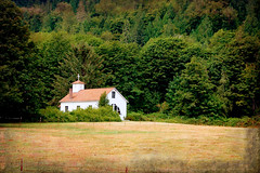
We pulled of at a nice roadside park with river access. After negotiating the gopher holes, we found a good spot for our picnic. I talked with someone who was leaving a vehicle, and using this as a take out spot for a rafting trip. Across from the park the mountains started to rise, with a small farm and old church right at their base.

Marblemount is the last significant town before getting up into the high country. Just past the town one enters the national park, proper, and the river takes on a wilder tone. At one point we reached a turn out for a gorge where American Whitewater had a booth set up. Several kayaks apparently were running a rapid that was out of view. Since it was crowded, we couldn’t really stop for a peek.
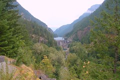
The community of Newhalem was established by Seattle Power and Light for workers building the huge dams on upstream. It’s not really a town, per se, but has a few streets and a general store. Just past the community the road becomes much more twisting and mountainous as it follows the river through a deep gorge. When the weather is clear, one can see snow-topped peaks along the Cascades.
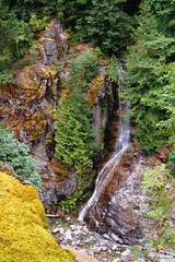
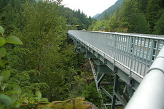
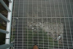
Through a couple of tunnels, and Highway 20 eventually reaches the Gorge Creek Dam. There are several overlooks along the way, but the most spectacular is Gorge Creek Falls. The road crosses the creek hundreds of feet in the air across a steel-grid bridge. There is a walkway along the bridge, and one can look straight down through the grid at the creek far below. I was the only one of our group to brave the walk.

The road drops down to the lake level then circles around to Colonial Creek. There is a park here where we have had numerous picnics. It was also one of Laura’s father’s favorite places to fish. This time, however, we didn’t stop, but continued on up the road.
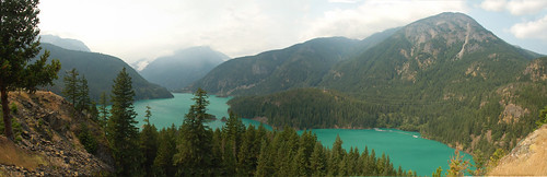
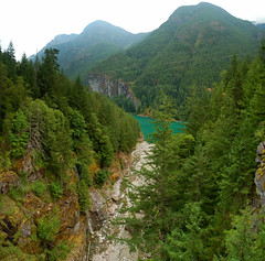
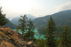
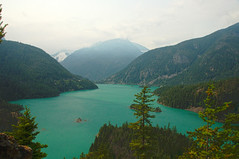
The Diablo Lake Overlook offers spectacular view of the lake and surrounding mountains. There are views of the snow packs, and the strange green-blue shade of the water is stunning. We lingered a bit as a chilly wind swept through the gorge.
We decided this was as good a place as any to turn around and head back. Continuing would have taken us deeper into the Cascades, and we already had a long ways to go to get home. The road back was uneventful – that is, until we got to Concrete. Apparently there had been an accident on Highway 20, so we were forced to go back the way we came, along the old Skagit Road. Unfortunately, this time we had all of the Highway 20 traffic along with us. Still, it was a great day out, and we were exhausted when we finally got back to the island.