UPDATE: This review was for the i-GotU GT-100. Mobile Action has contacted me and asked if I would try out the new GT-120. I’ve tested it, and posted the new results here. So far it’s worked much better than the GT-100 reviewed here, which has now been discontinued by Mobile Action. I’m leaving this review in place for archival purposes.
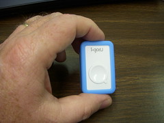
I’ve been test-driving the new i-gotU GPS tracker. It’s a tiny little device that looks more like a toy than an actual gadget. The silly name and baby-blue plastic wrapper don’t help that impression much. However, it’s simplicity (as well as its price) were what drew me to this tracker in the first place.
There were several arguments for using a dedicated tracker for geotagging photos as opposed to a handheld GPS. First and foremost is size. The i-gotU unit is small enough that it could be attached to a camera strap so that it’s always with the camera. It won’t get in the way like a larger unit might. Since these trackers don’t have LCD display screens, battery life tends to be much better. Usually data trackers like this have the latest GPS chipsets, so accuracy is improved. In order to see if these arguments held true for the i-gotU, I decided to put the tracker to the test and do a side-by-side comparison with my trusty Garmin eTrex Legend.
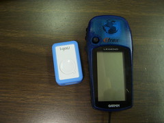
If it were just a matter of size, the i-gotU would win hands down. It’s probably one quarter the size of the Legend. However, that’s not all that needs to be considered. As far as I can tell, the i-gotU only records its location information at preset intervals. This interval can be set depending on the speed of travel. The default is 15 seconds for auto travel. You can set it for a longer interval, but the shortest is 5 seconds. This greatly affects battery life. At 15 seconds battery life is estimated at 20 hours. However, at 5 seconds, battery life is only 4 hours. “Walking Mode” records at 1 minute intervals, and has an estimated battery life of 40 hours.
The Garmin Legend, on the other hand, records location data continuously. While battery life may not be stellar (I’ve gotten about 3 hours with continuous use while geocaching), you do have the option of external power while you’re in a car. This discrepancy in how each unit records data does affect the accuracy of the GPS track. I had both units running on my way to work this morning. This is how Google Earth displays both tracks:
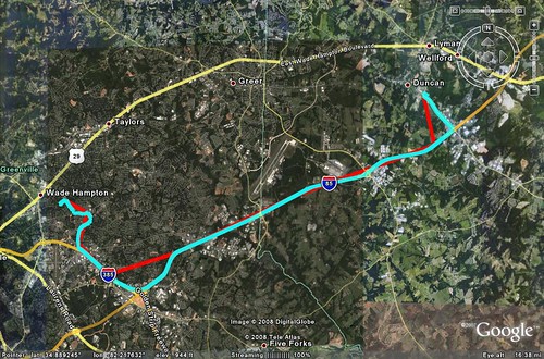
The Garmin track is in blue, and you can see that it more closely follows the correct path of the roads. The i-gotU track is in red, and doesn’t follow the roads accurately. The discrepancies look too great to attribute to just the 15 second interval tracking. It looks more like it couldn’t maintain a satellite lock, whereas the Garmin could.
The next step involved some actual geotagging. I tried to control for variables as much as I could. I set up my Nikon S50 on my dashboard in interval mode so that it would take a photo every 30 seconds. Since both the Garmin and the i-gotU get their time stamps from GPS signals, in theory all I had to do was set the camera to match one of them. Since the Garmin was the only one with a time display, that had to be the one. I cleared the memory in both units so that they were starting with fresh tracks, and I turned on both units at the same time.
My first run was at lunch. I turned on both GPSs and started the camera, then took a a quick run around the block on the way to lunch. I even set the camera to imprint the date/time on the images themselves just as another way to monitor things. The first results weren’t promising. I started with the Garmin and downloaded the track using EasyGPS. I synchronized the images with Geosetter, and it appeared to accurately geotag all 35 of my images. When I tried to download the GPS track from the i-gotU, there was nothing to download. There were no indications that the unit wasn’t working or that it hadn’t saved the file correctly. Of course, with only one button and two LED indicator lights, there’s not much way to tell if it is or isn’t working. So, as I was driving around thinking I had a GPS track, I got nothing.
So, lunch ended and I packed everything away and got back to work. I decided to give it one more try on the way home. I cleared both GPSs and set up the camera on the dash. It was raining, so I had my doubts as to whether or not I’d get a satellite lock on either unit. The Garmin eventually locked on, but I was never really sure if the i-gotU did or not. I kept pressing the waypoint button just to make sure it was working. Apparently, the blue LED is supposed to blink once every 15 seconds to coincide with the location marking. I didn’t see that happening.
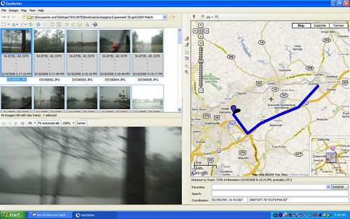
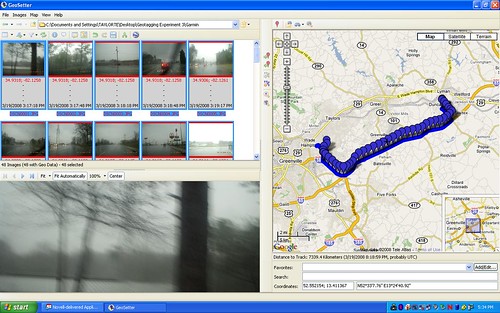
Back at home I downloaded the tracks from both units and started tagging. This time there was some data on the i-gotU. However, the tracks consisted mostly of three or four straight lines. When I geotagged the images, it placed all of them at the very end of the track. Not very useful. Below is a screen capture from Geosetter showing the results:
The Garmin had a very different result. The Geosetter screen capture shows the images evenly spaced along a fairly accurate track, just as it should be:
I hate to say it, but so far the i-gotU is even worse than useless. It gives one a false sense that it is working when it might not be. If you’re going to have to run a second GPS just as backup, you might as well have the one unit that you know works. The idea of a nice, light, simple device is appealing, but the reality is far different.
I haven’t totally given up. I want to repeat this one more time with clear skies and see what happens. Until such time, though, the i-gotU unit is a bust. I guess you do get what you pay for.
[tags]i-gotU, Garmin eTrex Legend, Garmin, GPS, geotagging, geotag, photography[/tags]
cheers for the review. looked to good to be true.
I agree, I was very excited about this until I found your review. Thanks for the heads up, looks like I saved $40.
Maybe if you only do car based photography, this isn’t the unit for you. I just bought one, walked around the block, and it tracked the route I took very well, with positions within give or take 15 foot.
Seems great for the price for those of us who don’t live in cars.
Actually, I do quite a bit of walking around photography, and this thing still couldn’t track well. Regardless, if you get one to work for you, then more power to you.
Hey, it looks like you only had five or size sample points.
How often were you logging (Under the advanced setting in the S/W)?
On July 1st I began working with a small group of musicians and sonic artists on the World Listening Project. Initially, it was proposed to collect and present field recordings from every country in the world to be presented as a website for the Chicago Calling Festival (October 1€”11, 2008).
Its purpose is now being revised. Under public discussion on the World Listening Project’s listserv http://launch.groups.yahoo.com/group/worldlistening/ are ideas that go beyond field recording and the creation of a sound mapping website. Some of this may include research and initiating geo-tagged audio projects.
It’s a junk, I need to get my refund. Is this made in China?
This item works effortlessly for myself and I can see no problems with it what so ever. You do have to read the instructions that come on the disc as they give you plenty of helpful advice. I have tried this both in my car and on my motorbike. In the car it was blue tak’d on the front of the dash with the button facing upward. On the bike it was just tied onto my handle bars with string.
http://img113.imageshack.us/img113/7934/58240468xk8.jpg
This is the motorbike results from today with the interval set to 5 seconds.
Please do give them a try. I honestly believe in them.
Maybe what we actually have here are QA issues, I’m very impressed with the easy way mine works.
I’ve experimented with it in the car and on foot and it just seems to work.
I tie wrap mine to my camera bag. You can press the button at any time to log your position you don’t have to rely on just the set interval.
For the price I cannot believe how good this device is.
Today I used it on the bike, time interval set to 1 sec. Works perfect!!! Even between buildings and in the forrest.
@trip PC is a nice program delivered with the receiver so you can see your speed over time, max , average etc.
Only thing I miss is altitude recording (I want to put the device in a RC plane).
Also usefull for surfing (water resistant).
I am wondering why the device supports only 16000 waypoints. Having a decent 20-meter poll interval (supposing the device supports distance intervals), only a 320km trip is supported, which clearly is not enough.
I don’t think flash chips are that expensive these days.
It’s fascinating to me the number of comments this review has engendered. As I state before, it didn’t work for me, but if it works for you – great!
My tests were done in a controlled situation over time, so I think they were very fair and thorough. For the company’s benefit, I hope that I just got a faulty unit.
I’m now using the QStarz BT-1000, and the better accuracy and features greatly make up for the increase in price and size.
Correction on my reply; Altitude info is also stored. When the data is loaded in A-Trip software the altitude is displayed over time or distance.
http://www.a-trip.com/tracks/view/6032
I bought this, not necessarily to match my track with pictures, but just to have a small discrete gps. So far it sux. I has not logged a sinle thing and it says it has. I’m not impressed and plan on sending it back.
I’d like to know what Andy is doing differently to us.. I just bought one of these and the routes it records are just wrong. I get spiky shapes appearing on the routes — it can’t even track me walking along a straight road.
It seems you guys don’t know this product very well. Let’s see how Julie in the-gadgeteer.com says about i-gotU. http://the-gadgeteer.com/2009/03/19/i-gotu-usb-gps-travel-logger-gt-120-review/
Lodaive – If you’ll notice, this product review was about the i-gotU GT-100, not the GT-120 as reviewed by Gadgeteer. The unit I had functioned EXACTLY as I described it.
From Julie’s description, it looks like Mobile Action has made some significant improvements with the GT-120, especially with the software that comes with the unit. I plan to do a new review with the GT-120 in the near future, and we will see how the improvements really stack up.
Seems to be very mixed opinions on this product. I Have used mine for six months running and driving. Only problems when I fail to let i start for a minute under clear sky before running off.
No problems with the route.
I don’t use the @trip software for more than taking the data out of the i-gotu and then exporting it.
It seems to me that the @trip software hides information from the route…
Maybe a Trackstick would do the trick.
Out of interest, does the Garmin have navigation functions? If it does, it will auto fit your GPS location to the nearest road. This may be why the Garmin trace follows the road exactly, instead of the IgotU which works solely by GPS position without trying to fit your route to a mapped road.
Just an idea 🙂