I came upon Kingville quite by accident. I was looking for information on another ghost town in Google Earth when I spotted this name near the confluence of the Congaree and Wateree Rivers. When I zoomed in a bit further I saw that the the place indicated by the name was all wooded – there was no town there. Street View also showed just a wooded area, and not enough buildings to even justify keeping this as a place name. This intrigued me, so I did a bit of research, and it turned out to be an interesting ghost town location itself.
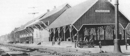
According to information on the Kingville Historical Foundation’s website, the town got it’s start in 1842 when a spur railroad line from Aiken was completed to Columbia. I checked Robert Mill’s 1825 atlas of the area, and the name Kingville does not appear. In 1850 a branch line was completed to Camden, and the town began to grow because it was now located at the juncture of two major railroad lines.
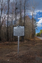
Research on the town was initially confusing. According to the historical marker for the site…
Kingville is thought to be named for its status as “king” of the railroad line between Charleston and Columbia and between Columbia and Camden.
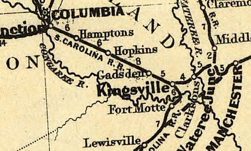
However, the town was first called “Kingsville” with an “s”. For awhile I wasn’t sure if I was finding information on the same town. For example, this is an excerpt from an 1870 map of the Port Royal railroad in the southern states. It clearly shows the spelling with an “s”. The town’s name on this map makes it look almost as big as Columbia, but this is deceptive. Since this was a railroad map, the emphasis was on major junctions, rather than the actual towns.
The town really gained prominence during the Civil War as a supply stop for the Confederate Army. According to researcher Elizabeth Almie, ‘Many diaries, memoirs, and other records mention traveling through Kingville and the wayside hospital established there by the Young Ladies’ Hospital Association in order to “provide food and drink for all men in uniform and aid the sick and injured in transit.'”
Even though it was an important junction, many visitors, especially those from out of state, weren’t too keen on hanging out on the edge of a swamp. According to Almie, several visitors reported in their journals that “they seemed generally to dislike Kingville as a dismal outpost on the edge of a swamp, but knew its importance as a transportation facility, as a hospital and as a site of relief work that served the soldiers.” Almie goes on to say that even as late as 1907 a newspaper article “called Kingville ‘simply a ‘death hole’ during the summer and fall months.’ That article went on to state that the railroad employees were willing to forego their expenses as long as they did not have to spend the night at Kingville.”
At the end of the Civil War Sherman’s troops came through and really made a mess of things. According to a survey of the area for the National Register of Historical Places…
The county was particularly stricken by the Civil War, but precise property losses are difficult to calculate. Troops under the command of General Edward E. Potter destroyed a great deal of property from the Kingville vicinity to Coumbia, much of it owned by the railroad. On the Congaree River, the bridge and about one hundred feet of contiguous trestling were burned. At Kingville, flames consumed he hotel, depots, agent’s house, and about three-thousand feet of track. The depot at Gadsden, the water tank, three-hundred feet of track, and eight freight cars were wiped out.
Sherman’s troops took the destroyed track and made “Sherman’s neckties”, pieces of rail twisted around trees.
In Reconstruction days the depot was rebuilt, as was a sawmill and other businesses. Much of Lower Richland was sold to newly freed African Americans as part of a land redistribution program. The town rebounded and continued as an important railroad junction until 1908, when it was devastated by floods that hit the entire state. According to the Times and Democrat of Orangeburg, the Wateree and the Santee backed up into the swamp and flooded the area.
Every home abandoned – water surrounding the village on every side – no avenue of communication – shut off from the world – was the fate of Kingville….The water was up on an average of seven feet around the station at Kingville this extended at about the same average depth in every direction….The stateion at Kingville was half covered with water and not at any point as far as the eye could reach was [sic] the tracks of the Southern visible.
The Watchman and Southron of Sumter reported another flood in 1916, and again in 1929. In addition to the floods, changing transportation routes and cotton boll weevil infestations helped send the town into further decline. Then came the Great Depression. By that time, most of the area was owned by the Holly Hill Lumber Company. According to Joe Wilson, who was born in the town in 1926, Holly Hill bought out the remaining residents, who moved a couple of miles north of the town’s location.
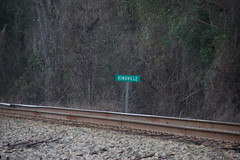
So that’s the history of the town, and how it died out. As for what remains now, we discovered that upon our visit yesterday. There was the historical marker, and on the tracks a sign that reads “Kingville”.
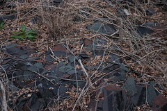
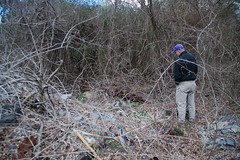
We found several piles of debris, especially piles of shingles, as if a building had collapsed on that spot. The shingles looked a bit too modern to fit the age of the town.
Mr. Wilson told us that Holly Hill had erected sheds and temporary housing for the lumber workers. It would make sense that this debris is the remains of those later structures.
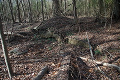
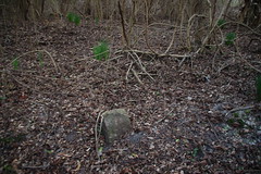
In the woods, however, we came upon several stone foundations and what were clearly streets for the area.
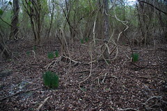
One real clue was the presence of clumps of daffodils. Often these are found around old home places, and are an indication of previous habitation. We used to look for these tale-tell signs when we were out exploring other areas. We found several in this area.
Mr. Wilson said that the hotel ruins were on the other side of the street from where we were exploring. However, we didn’t have time to explore that section.
The Kingville Historical Foundation sponsors a reunion every year in October. This is a good time to learn more about the community and its history. However, even though there is a community surrounding area, Kingville truly is now a ghost town.


That’s really interesting. I didn’t know so much of lower Richland was sold to blacks back in the day. A black family at our church has lived in the Hopkins area for several generations (I believe). Maybe they are descended for people who got the land back then.
Very interesting…….Yes blacks own a lot of land in Richland County
Where’s the occupant?
Found a story in The State about the 2011 Kingville reunion you may be interested in:
http://www.thestate.com/2011/10/30/2028105/return-to-kingville.html
That top picture, the shed, reminds me a lot of a peach shed that used to stand on SC 296 just west of Reidville. The shed was at a point, if I recall, where the road veered left, and made a great visual statement. In the time I recall, that entire area was thick with beautiful peach orchards. Oh how I miss those days! Spartanburg County had some remarkable orchards.
I know right where that shed is. It still there, but unfortunately the orchards have been swallowed up by housing developments.
A few years ago, I transcribed the 1903 diary of my great-grandfather. It’s his first year in Congress, the year of the huge flood of the Pacolet River, and other stuff. Currently, I’m adding hyperlinks, and I’m including this page of yours because he mentions Kingville a few times: he and friends went fishing somewhere between there and Gadsden.
I was curious if you knew where the original repository was for the Kingville station photo. Thanks!
Robert, if you click on the photo you’ll see a caption that shows that it is from the Palmetto Leader newspaper, circa 1917.
Oh great! Do you by chance know where I can find a copy of that newspaper?
Do you know anything about a plantation called Stony Hill, owned by Lt Col Warren Adams CSA supposedly located at Kingville?
I’ve not hear of that one. I tried checking the South Carolina Plantations reference page, and it doesn’t show up there. There is a Stoney Hill community in Newberry County west of Prosperity that still has a post office.
where you on the wooded side of griffind creek road when you photographed the ruins?
I was born approximately one mile north of Kingville and spent many hours walking the Southern railroad tracks which extended to the northern US. I attended elementary school (a two room building housing grades (1-6)) at Stoney Hill elementary before going to high school at Webber, HS, Eastover, SC. Life was very simple.
Hey Oliver, would you happen to know where those ruin foundations are located that Tom took photos of? I am familiar with the topography of the area, if you know, could u point me to them using the intersection of king ills Rd and griffin creek road. Say we are at the intersection facing or looking toward the tracks. Thanks
Kanayo, sorry I hadn’t responded. The time leading up the Christmas is crazy for me. I found the ruins just northwest of the intersection of Kingville Road with Griffins Creek Road. There is a little spur road that heads towards the track, and it’s just south of that road. Here’s a Google Maps link. https://goo.gl/maps/
Also, this historical marker is before you get to the corner with the ruins. http://www.hmdb.org/marker.asp?marker=43643
Thanks so much Tom, I really appreciate it. Such a rich history for a place that we here nothing about. Many many letters from the era mention Kingsville. Thanks a million.
If you find anything new, I’d love to hear about it!
The Joyner’s owned 3000 acres from west of Griffen Creek to Joe’s Branch . I am trying to locate Joe’s branch off one of the other creeks.
I been told Absolom Joyner donated the land for the church on fork church rd.. My grandmother had two uncles that died in infancy in the Joyner cemetery that shows up on Bluff rd. on several maps. Peter Seymour Rd. was named after her Uncle’s Saxby Joyner’s kid (her cousin) even though she did not like his practices.
excerpt from Carolana.com…http://www.carolana.com/SC/Transportation/railroads/sc_rrs_sc.html
Of special interest was the establishment in 1856 of night accommodations between Charleston and Columbia. In making the announcement on April 22nd, the Daily Carolina Times of Columbia stated that the cars would be fitted up expressly for the accommodation of night travelers, and further comments that “this will be a very desirable acquisition to the road, as it is extremely irksome to persons in delicate health to sit up all night, and even those more robust feel the effects of a night trip to Charleston, on the following day.” Night service was also established between Charleston and Augusta, and between Augusta and Kingsville by way of Branchville.
All I knew about Kingsville before tonight is that Mary Boykin Chesnut, on her way from Charleston South Carolina to Camden South Carolina, met her husband, US Senator James Chesnut returning from Washington DC to in Kingsville. The date was AFTER November 10th 1860, after the senator resigned his seat upon South Carolina’s secession from the union. This information is in Mary Boykin Chesnut: a biography edited by Elisabeth Muhlenfeld, Louisiana State University press, 1992 paperback version, page 96. It is possible that there is more information about Kingsville in Vann Woodward’s Mary Chestnuts’ Civil War, A now classic Historical work.
Sent from my iPhone
Really appreciate this work! Most of the world still doesn’t know about Kingsville; best part of your work for me is the history you gave us on Sherman’s doings and the Civil War function of the town. Based on the Carolana railroad map for 1960, I thought the town might be between Gadsden and Ft. motte, but opened a few inconclusive sites before I found yours. Was re-reading Chesnut book and wanted to know where the town was. Roadside thoughts.com was asking if anyone knew where it was so I forwarded your site address to them. Love it when I come across sites that evidence an interest in our history…Thanks!