The Google Earth Blog recently had an article about how rooftop architecture is changing because of visibility in mapping programs such as GE. Having recently commented on the trend in this blog, I read the entry with interest. One of the things that really caught my eye was the design of the new Dubai Palm man-made island and its visibility from above.
I hadn’t paid much attention to Dubai until my recent trip to London. There were advertisements everywhere, offering various resort properties in the city. It struck me as odd that a place so far away from England was being so heavily promoted. Of course, I was forgetting how diverse England’s population is and it’s close links to the Arab world.
With my attention turned back to Dubai by the GE Blog article, I started looking for more information. It seems that they have several "world’s largest" construction projects underway. First, there are the islands, as seen in this screen capture from Google Earth…
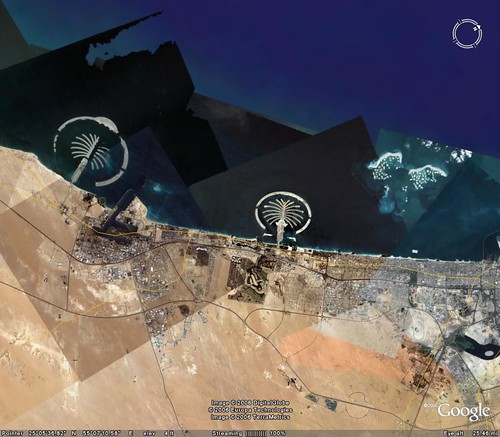
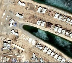
Talk about terraforming! It’s amazing what you can do with unlimited oil wealth and little regard for the environment. The islands are still under construction in this view, and are supposed to give the impression of palms. Each palm "frond" is enormous, with luxury villas and hotels. Below is a closer view of the smaller of the two island sets, the one on the right. This one is further along in construction.
When completed, there will be three "Palms", adding about 520 KM of beachfront property to the Dubai coastline. It is said that the Palm Deira, largest of the three, will be larger than Paris.
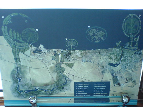
Back to the first image – one can also see another nebulous cluster of islands on the right side of the image. The Google Earth imagery hasn’t quite kept up with construction. These are the World Islands, which roughly portray a map of the world. Each island has either an exclusive villa or hotel, and is only accessible by boat. The image below by Flickr photographer Pedrillo shows a more complete version.

The photo below was taken by Flickr photographer Rubbber Duckyyy and shows a map of the completed Dubai Islands project.
Terraforming isn’t the only SciFi related concept Dubai has taken to heart. Also under construction in the city is the Burj Dubai, which will be the tallest building in the world by far.
 This artist’s rendering, courtest of Flickr’s Weisheng, shows how tall the building will be against the Dubai skyline. The chart below shows the height relative to current "world’s tallest" buildings.

Based on this chart, the Burj will be adouble the height of the Empire State Building. Oddly enough, it has a triangular footprint similar to the Ryugyong Hotel in Pyongyang, North Korea, only narrower and much, much taller. Let’s just hope this building doesn’t suffer the same fate as the Ryugyong.
The Burj Dubai will be unique not only for its extreme height, but for what it will contain. There will be actual apartments, shopping, and restaurants in addition to office space. It’s supposed to be a complete community. If you had both your office and apartment in the Burj, it’s conceivable that you might never have to leave the tower.
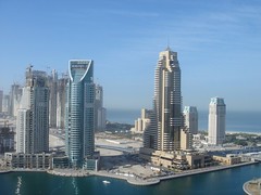
All of these projects are scheduled for completion in the next 5-10 years. However, take a look at what has already been completed. The Governor’s House in Dubai and the surrounding buildings which make up the Dubai Marina Project already look like something out of a futuristic movie set.
That amount of construction requires wealth and implies exclusivity. I’d love to visit sometime, but doubt I could ever afford it. I just hope the United Arab Emirates remains free from the rest of the turmoil plaguing the area.