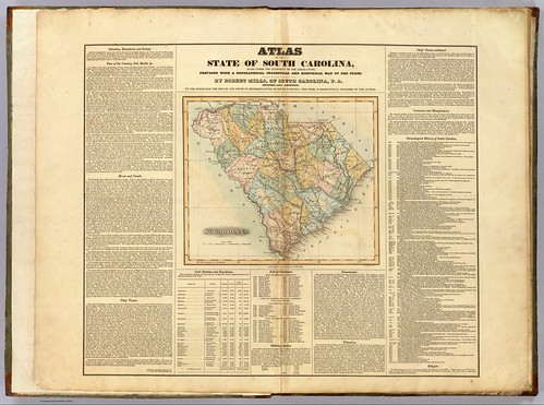
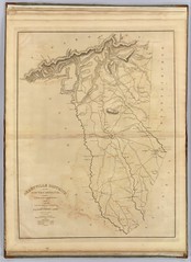
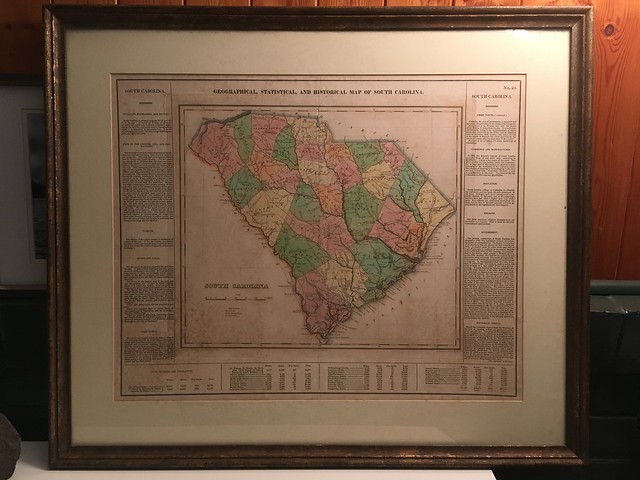
Random Connections

Welcome to a random collection of rants, reviews, and miscellaneous thoughts on everything from instructional technology to local restaurants. Feel free to stay awhile, and add a comment or two if so inspired.

US 1

When I was about 12 years old my brother-in-law gave me a Rand McNally Road Atlas.  I had already been collecting maps for some time, so having an atlas with a map of every state in the US was a dream come true.  I pored over every state, plotting out extended road trips.

One road that especially caught my attention was US 1.  First, there was its primacy in the numerical highway system.  It must be important if it’s number 1.  Then, there was the route.  It runs all the way from Key West, Florida, to the northernmost point in Fort Kent, Maine.  And finally, there were all of the interesting cities that it connected – places I’d never been, such as Washington, D. C., Philadelphia, New York, and Boston.  It seemed like the perfect highway to me.

Recently I’ve had the occasion to drive different segments of US 1 – in Columbia last week, in Florida two weeks ago, and in Maine over this past summer.   The recent jaunts on this highway rekindled my interest, so I started exploring the route in Google Earth, and trying to find out what I could about its history. (more…)

DARPA Challenge Update

Well, that didn’t take long.  By 5:00 PM DARPA had already announced a winner in their 2009 Challenge.  The challenge was supposed to last through December 14, but it was obvious from early on that it wouldn’t take that much time.  As shown on the map above, the balloons were located in places where it would have been hard to miss them (although there is a large wedge of the Midwest with no ballooons.)  The winner was the team from MIT.

I didn’t participate in the challenge as I thought I might.  However, I did check in on the progress from time-to-time on Twitter.  It was interesting to watch the competition progress.  Most of the Twitter traffic seemed to be from those involved in the hunt, and I saw only one from someone that seemed to have honestly stumbled upon one (…sort of, but more on that in a bit.)

As I saw reports of balloons I wondered if I shouldn’t try to find the location and report them as my own.  However, I figured that if the reports were THAT public, then others would have reported them.  I just decided to watch the spectacle. (more…)

99 Red Balloons

You and I in a little toy shop,
Buy a bag of balloons with the money we’ve got.
Set them free at the break of dawn
‘Til one by one, they were gone…

Actually, it’s 99 minus 89, but references to the 1980′s hit by Nena are inevitable.  To celebrate the 40th anniversary of the Internet, DARPA has come up with a creative challenge “that will explore the roles the Internet and social networking play in the timely communication, wide-area team-building, and urgent mobilization required to solve broad-scope, time-critical problems.”

According to the challenge website ten red, eight-foot weather balloons will be tethered to locations around the United States.  The first person (or team) to provide the latitude and longitude of all balloons will win a $40,000 prize.

CNN.com quotes Johanna Jones, a spokeswoman for DARPA, and provides a few more details…

At 10 a.m. ET, the 8-foot-wide red weather balloons will be released on property accessible to the public.

“They’re not going to be out in the middle of nowhere,” Jones said. “They’re going to be near places where there is traffic.”

She said the balloons will be tethered and will remain aloft for at least six hours. Each will be accompanied by a DARPA representative.

The first person to report the latitude and longitude coordinates of all 10 balloons will win the prize. The competition will remain open until December 14.

Nationwide balloon-hunt contest tests online networking
By Doug Gross, CNN
December 4, 2009

So, the balloons will only be aloft for a few hours on one day. That means no individual could travel to all 10 locations. Seekers will be forced to search for references to the balloons and reports in social media such as Twitter, Facebook, or Flickr. That is, of course, assuming someone reports the sighting and is willing to provide coordinates. If I didn’t already know about the challenge, I doubt I would stop and Tweet about a red balloon, giving its lat/long coordinates. (more…)

  • 2 Comments
  • Filed under: Internet, Weirdness
  • South Carolina Rivers

    File – Paddling South Carolina Rivers (KMZ, 1.5 MB)

    Google Earth has been one of the best resources for planning river kayaking trips, especially on new routes with which I’m not familiar.  I’ll scan the route, locate put-in and take-out points, and put placemarks for certain landmarks such as rapids, powerlines, bridges, tributaries, or other interesting locations along the way.  I would then use GPS Babel to convert my Google Earth files to GPX files then upload the data to my GPS so I would have it with me on the paddling trip.

    Pretty soon I had a nice little collection of river trips in Google Earth.  I began to wonder if anyone else was doing this.  It seemed like it would be an excellent resource.  There are some excellent books out there, such as Able and Horman’s Paddling South Carolina, and while the maps in these resources are fine for giving driving directions, there is no GPS information.  SCTrails.net has started putting Lat/Long coordinates for some of their paddling trails, but not for all of them.  So, I decided to make my own collection. (more…)

    Getting More from Your Auto GPS

    I figured it was time for a round-up.  I’ve been talking a lot about doing various things with a GPS, but haven’t gone into much detail.  Chances are that you got a GPS for your car because you feel like you’re directionally challenged, or you just the convenience of plugging in an address and getting directions.  That’s about the extent of what most people do, but there is so much more.

    Thought it might be time to talk about automobile GPSs in general, and how they can really benefit a serious rambler like myself.  The one I use is a Garmin Nuvi 205, but most of what I’ll cover here should work with just about any unit.  If you’re into geocaching, you’ll already be familiar with most of these concepts. (more…)


    Visit Random Connections

    PhotoStream

      Latest Photos...
      Chip and AnnaLaura, Houston, and ChipGlynda and OliviaOlivia and her great unclesPaparazziOlivia Standing
      More Photos...
    www.flickr.com
    This is a Flickr badge showing photos in a set called general. Make your own badge here.

    Social Homes

    del.icio.us  Flickr  YouTube  Twitter  Last.fm  VIRB°  FriendFeed  Facebook