File – Paddling South Carolina Rivers (KMZ, 1.5 MB)
Google Earth has been one of the best resources for planning river kayaking trips, especially on new routes with which I’m not familiar. I’ll scan the route, locate put-in and take-out points, and put placemarks for certain landmarks such as rapids, powerlines, bridges, tributaries, or other interesting locations along the way. I would then use GPS Babel to convert my Google Earth files to GPX files then upload the data to my GPS so I would have it with me on the paddling trip.
Pretty soon I had a nice little collection of river trips in Google Earth. I began to wonder if anyone else was doing this. It seemed like it would be an excellent resource. There are some excellent books out there, such as Able and Horman’s Paddling South Carolina, and while the maps in these resources are fine for giving driving directions, there is no GPS information. SCTrails.net has started putting Lat/Long coordinates for some of their paddling trails, but not for all of them. So, I decided to make my own collection.
 I knew when I started that I had to set some ground rules. I decided to focus only on rivers. Specifically, I was looking for trips that go from point A to B with some kind of current. The route is limited by the physical nature of the body of water. I included only easily navigated rivers, and excluded those that are too narrow, such as upper reaches of the Enoree and branches of the Tyger and Saluda. These may be run after a good rain by folks with creek boats, but they may be too much trouble for most paddlers.
There are also lots of great flatwater paddling opportunities on ponds and lakes in our state, but I decided to exclude those, or this project would get out of hand. As I tried to adhere to this rule I ran into some gray areas. Coastal rivers, in particular, became a problem. Are tides sufficient enough to be called a “current”? If the coastal river was part of a larger paddle route, such as the Edisto, I included it. However, if the river was primarily just part of an estuary system, such as the May river, I didn’t include it. There was also the problem with dammed (damned) rivers that didn’t form a large lake. I included these only if that portion was part of a larger paddling route. Not to exclude these wonderful still water paddling opportunities, I did include a section listing all of the SC DNR boat ramps in the file.
Before I got started, I tried to see if someone else had create a similar resource. A paddler in Florida created something similar for that state and uploaded it to the Google Earth Community. Unfortunately, I didn’t find anything similar for South Carolina. There was, however, some excellent hydrology GIS resources from the South Carolina Department of Natural Resources. I used some of these as a base for my project, importing them into ArcGIS then exporting them as KML files for inclusion in Google Earth.
 The rest of the project had to be done manually. Using all the river guides I could find, both printed and online, I started plotting paddling routes. I started this when I had the flu a couple of weeks ago, and continued it in the evenings while sitting in front of the TV. It’s been a fascinating virtual trip through our state, and I now want explore even more of these rivers.
One thing that struck me was that South Carolina still has large stretches of rivers that are still essentially wilderness. The lower part of the state has long stretches along the Little Pee Dee and Edisto Rivers that are bordered by swamp lands, but even some of the Midlands rivers, particularly the Wateree and Congaree, have very limited access.
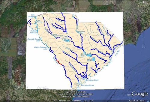
I divided the rivers into three main groups – Upstate, Midlands and Lowcountry, and Coastal. This is a bit different from how others divide the state, but I’ve got my reasons, as follows:
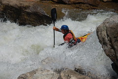
- Upstate – these are rivers above the Fall Line. The rivers tend to be narrower, a bit shallower, and have a strong current. There are often shoals or rapids that have to be negotiated.
- Midlands and Lowcountry – these are rivers below the Fall Line. These rivers tend to become broader and meander through swamp lands. Usually there is still a good current.
- Coastal – these are rivers along the coast (duh) that come under the effect of tidal forces. In this section I only included rivers that begin and end in tidal zones. For example, the Edisto does not fall into this section because it originates in the Lowcountry section, but it does extend to the coast and the ACE Basin.
In addition to the river routes and access points, I included landmarks only the way. Some of these are easily recognized in Google Earth, such as bridges and powerlines. Obvious historic landmarks were included. I also used my South Carolina Place Names Database, which includes USGS GNIS data, to locate historic landings, ferries, and mills along the routes.
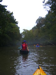
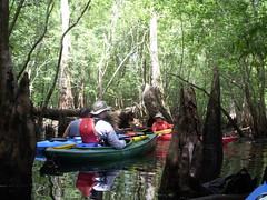
Finally, I used the Panoramio layer in Google Earth and Metaltoad’s Flickr Google Earth network file to locate photos along the river routes. I copied these into the appropriate folders, as well, so that there are images of each of these rivers.
The total came to 41 rivers in South Carolina. Here’s the list…
Upstate – 14
North Saluda River
Tyger River
Broad River
Catawba River
Chattooga River
Chauga River
Enoree River
Saluda River
Reedy River
Pacolet River
North Tyger River
South Tyger River
Turkey Creek – Stevens Creek
Lawson’s Fork CreekMidlands to Lowcountry – 17
Pocotaligo River
Ediston North Fork
Black River Congaree River
Cedar Creek
Edisto River
Wateree River
Lynches River
Little Pee Dee River
Savannah River
Edisto South Fork
Santee River
Lumber River
Great Pee Dee River
Salkehatchie
Four Holes Swamp
Black Mingo Creek
Peter’s CreekCoastal – 13
Wando River
Ashley River
Cooper River
Combahee River
Ashepoo River
Cuckhold’s Creek
North Santee River
Wambaw Creek
Cheraw River
Horseshoe Creek
Chessie Creek
Waccamaw River
Cossawhatchie River
Each river is placed in its own folder with subfolders for River Access, Paddle Routes, Points of Interest, and Photos and Videos. I tried not to editorialize with descriptions of the rivers. Any descriptions come from the resources themselves.
How to Use the File…
 It goes without saying that you need Google Earth in order to view the file. The file is rather large and cluttered, so I wouldn’t recommend turning on all of the folders at once. Select a folder and zoom in, then turn on only that folder. You can save each river folder as a separate KML file, then convert the file to a GPX file for your GPS using GPS Babel. The routes were as accurate as I could get them using Google Earth, and will uploade to your GPS as well.
I’ve also included a folder for Resources. These include my source materials, an overlay graphic of major river systems in the state, and an overlay of the Fall Line from SC DNR data. There are also two network layers – one from American Whitewater showing flow rates and difficulty classifications for whitewater rivers in the state, and one from USGS showing flow rates and water levels from gauging stations around the state.
Credits
Here is the rather extensive list of resources I used to complete this project…
Books
Able, Gene and Jack Horan. Paddling South Carolina: A Guide to Palmetto State River Trails. Revised Edition. Orangeburg, SC: Sandlapper Press, 2001
Beasley, Barry and Tom Blagden, Jr. The Rivers of South Carolina. Englewoood, CO: Westcliffe Publishers, Inc. 1999
Benner, Bob and David Benner. Carolina White Water A Paddler’s Guide to the Western Carolinas. Seventh Edition. Birmingham, AL: Menasha Ridge Press, 1993
Boyd, Brian A. Chattooga Wild and Scenic River. Revised Third Edition. Clayton, GA: Fern Creek Press, 2001
Earhart, Ralph. Kayak Charleston: A Guide to Trips within 1 Hour of Charleston. Charleston, SC: R. Earhart, 2004
Jackson, Jeff and Dave Hargett. Reedy River Paddling Trail: Greenville, SC to Lake Greenwood. Brochure. Greenville, SC: Friends of the Reedy River, 1999
Taylor, David and Gary Henderson. The Lawson’s Fork: Headwaters to Confluence. Spartanburg, SC: Hub City Press, 2000
South Carolina Atlas & Gazetteer. First Edition. Yarmouth, ME; Delorme, 1998
Web Resources (in no particular order)
These are most of the web resources referenced in this project. These are in no particular order…
RiverVenture – an excellent educational tool about the rivers in South Carolina produced by my good friend Patrick Hayes at SCETV – http://www.riverventure.org
Sciway – a privately funded website with just about anything anyone would want to know about South Carolina – http://www.sciway.net
American Whitewater – http://www.americanwhitewater.org/content/River/state-summary/state/SC/
SC Trails – an excellent online resource for planning paddling trips – http://www.sctrails.net/Trails/ALLTRAILS/WaterTrails/WATERTRAILS.html
Paddling.net – Kayaking and Canoeing in South Carolina – http://www.paddling.net/places/SC/
Riverfacts.com – South Carolina Whitewater – http://www.riverfacts.com/states/sc.html
USGS – Water Resources of the United States – http://sc.water.usgs.gov/
US Forest Service – Broad River – http://www.fs.fed.us/r8/fms/sumter/recreation/BroadRiver.php
US Forest Service – Enoree River – http://www.fs.fed.us/r8/fms/sumter/recreation/EnoreeRiverCanoeTrail.php
GORP – Enoree River Paddling Trail – http://gorp.away.com/gorp/resource/us_river/sc_enore.htm
Paddling.net – Trip Reports for South Carolina – http://www.paddling.net/places/SC/
Friends of the Edisto – http://www.edistofriends.org/
Greenville County Planning Commission – Saluda Paddling Guide – http://www.greenvillecounty.org/gcpc/transportation_planning.asp
Catawba River Keepers – http://www.catawbariverkeeper.org/
Duke Energy – Catawba Canoe Trail – http://www.duke-energy.com/lakes/catawba-river-canoe-trail-map.asp
American Rivers – Southeastern Rivers – http://www.americanrivers.org/your-region/southeast/
Aweigh – Collection of South Carolina paddling information from paddler Dennis Biby – http://www.aweigh.com/kayaking
South Carolina Department of Natural Resources – Scenic River Designations – http://www.dnr.sc.gov/water/envaff/river/scenic_act.html
Brown€™s Guide to Georgia – Savannah River Guide – http://brownsguides.com/srl/savannah-river-paddling-guide/
Savannah River Kayak Trip – personal trip report – http://www.mudspike.com/savannah.htm
ACE Basin – Canoe Trails – http://www.acebasin.net/canoe.html
ACE Basin – Boat Landings – http://www.acebasin.net/boatlanding.html
Palmetto Paddlers – Trip reports from rivers throughout the state – http://www.palmettopaddlers.org
USGS Geographic Name Information Service – http://geonames.usgs.gov/pls/gnispublic
RandomConnections – South Carolina Place Names – https://www.randomconnections.com/scplacenames/
South Carolina DNR GIS Hydrology Data – http://www.dnr.sc.gov/gis.html
So, enjoy, and please send feedback about the file.
This is a great resource! I am fairly new to paddling but enjoy it just the same. I have done trip marking with my GPS and converted it over to KML files for uploads to Google Earth and then over to my Google Maps page.
http://tinyurl.com/yz68qjm
I love what you are doing and hope that I can learn more along the way.
Was wondering if you thought about donating what you have done to OpenStreetMap or EveryTrail? http://www.openstreetmap.org/
http://www.everytrail.com/
I have been checking into those guys for new trails and maps and it seems as if SC needs some help in the areas.
Trying to go paddling this Sunday so I will see if I can take this we me for a handy guide! Thanks.
I’ll have to check this out. One name that is missing, probably because it’s not really paddled much yet, is the 12 Mile River or 12 Mile Creek (whichever it is). Two of the three dams on that stream will come down (hopefully, finally) in the next 2 years, and the supervising judge is trying to get the third removed. It’ll likely be worth looking at, and may be now for all I know. Lots of open stream down through there.
Ken – I had considered, but dismissed 12 Mile because it’s still not ready for prime time. I’m hoping that version 2.0 of the list will include it.
Andre – I hadn’t thought about contributing to those websites, but I may consider it. I’ll scan them to see if I left anything out of my list.
I was happy to see “The Lawson’s Fork…” by David Taylor and myself used as a reference. Thanks.
Gary – It’s a great book, and I enjoyed the video, too. Our high school library had a copy of that. I would love to create a project like that – you’ve captured Lawson’s Fork wonderfully.
You put a lot of work into this project and the result is AWESOME. Although I don’t have a boat yet, I still have it in my wish list and I’ll be back for your maps when I do.
Having grown up in Sparkle City, I’d love to see the Lawson’s Fork stuff.
Great work Tom. Thanks for taking the time to create the map. Now you can start to incorporate live tidal info for the coastal rivers and streams, and live or near live hydrology data from gauging stations.
I spent most of my free time fishing the Combahee River with my father during the 60s & 70s. From Tar Bluff up to the rr trestle near Yemasse. An extended float trip down Cuckold Creek to Tar Bluff is in my bucket list.
Not a bad idea, Joe. If I can find a network KML file from NOAA or somewhere like that, I may incorporate it.
Joe – ask and ye shall receive. I found some suitable information from EarthNC.com and added it as a network layer under the Resources folder. I’ve just updated the file online. Thanks for the suggestion!
Tom,
Nice work with the KMZ file for SC Rivers.
I hope to paddle some of the Saluda River above what is shown in the “Paddling SC” book. I am interested in more details for the sections you show on the map for the Saluda upstream of Lake Greenwood. Can you point me to any references for these?
Best regards,
Paul
Tom,
I think I found the references. I see AW has some info on what they call Saluda 1, 2, and 3.
I found a planning guide by the Greenville Co. Parks and Rec on Pearson Access to Saluda Lake Landing, and your report on Freeman Bridge to Hunts Bridge.
Best regards,
Paul
Paul – you found it before I had a chance to look for it. You might also check the websites for the Foothills Paddling Club and Palmetto Paddlers. I think they might have some trip reports from those sections.
Tom – We made some runs on the Saluda and enjoyed them.
We also tried to paddle from downstream of the Piedmont Dam to Timmerman Landing in Pelzer but did not find a suitable put-in in Piedmont.
The Piedmont access marked on your kmz file appears to be off a driveway at Spring Street in Piedmont. The driveway has a locked gate and goes a few hundred yards to what appears to be a small utility operation. It would be possible to park on the street and carry in, but we decided not to.
Looking at property records, the driveway crosses the property of many privately-owned tracts. Piedmont Sewer and Light District owns only a small tract around the utility. I assume they have an easement along the driveway.
We asked several people in Piedmont about river access, but we did not come up with a decent one. Do you know any more about the status of possible river access in Piedmont?
Paul,
Thanks for the heads up on the access. My sources have shown this as an informal access point, and it may no longer be available. I looked on the Greenville Planning Commission’s guide to Saluda River, and it states that “At this time, a trip beginning at the Timmerman Landing should end at the same site.” That leads me to believe that there might not be access to the river below the dam at Piedmont. Here’s a link to that PDF file…
http://www.greenvillecounty.org/gcpc/transportation_planning/pdf/timmerman_landing_paddling.pdf
Thank you for doing this! Im just getting into kayaking and live in Due West. My wife and I are going to do upper Saluda River this weekend! Maybe something you could add (or I missed it) is travel time for the ones you know?
I would like to prepare a Google Map for a kayak paddle showing a few landmarks, download the map and then place it on a GPS. Then on the water have the Google Map display my kayak location on my Google Map during the trip. Is that possible?
David, here’s how to do it…First create your landmarks and the route in Google Earth. The route can be drawn out as a path. Save all of that in a Google Earth folder, then save the folder as a KML (not KMZ) file. Use GSP Babel (www.gpsbabel.org) to convert the KML file to a GPX file. From there you can either use the program that came with your GPS to transfer the GPX file to the unit, or you can use EasyGPS (www.easygps.com). Hope this helps!
Thanks so much – I am learning so much! I took a sample kayak route and put a route and waypoints on a Google Earth kml file. Used GPSBable to convert to a GPX. Then placed the GPX file on a Garmin Nuvi 205W but I only got waypoints – NO route. Worked with options in GPSBable but no success yet. Any suggestions?
David, there may be a setting to convert paths to routes. Now that I think about it, I’ve just used waypoints and not the routes.
Tom,
You note Oxbow Road as an access on the Wateree River. I paddled the Wateree River a few years ago and stopped to checkout possible access at Oxbow Road. I noted it was a rather steep bank to use, and the road (drive) was very narrow.
In looking at SC DOT maps for Sumter County, it does not show a public road here, and the GIS county maps show this tract as private property.
Are you sure access here is legal without permission from the owner?
Thanks,
Paul
Hi. I didn’t read every comment, so maybe what I want to ask is covered there, but I have moved here from Michigan and have a question. Northern Michigan has many beautiful rivers and for many of them there are canoe liveries which will rent you a canoe and then you can canoe downstream for various trips like 3 hour trip or 5 hour trip, etc., and then the livery would come and pick you up. Most rivers are 1 – 2 and canoeble by most, but the point is that the livery comes and picks you up and then takes you back to the livery and your car. I have been looking for the same kind of business/service here in SC, but have yet to find it. Is this available ? thanks