Skip to content

Random Connections

A collection of photography and exploration focusing on Upstate South Carolina and beyond.

  • Home
  • About Us
  • Photos
  • Resources
  • Other Voices
  • Post Archives
  • Home
  • 2011
  • August

Month: August 2011

Quick Jaunt to Cunningham

Posted on August 28, 2011 By Tom 1 Comment on Quick Jaunt to Cunningham
Paddling

Lake Cunningham-13

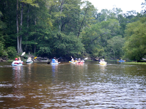
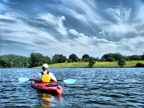
One of the things I love about where I live is that I can be on the water paddling somewhere within 15 minutes. Such was the case Saturday. While Irene was wreaking havoc along the coast, we had wonderful weather, albeit a bit breezy. I called up Tim Taylor, and we loaded up the boats for a spur-of-the-minute paddling trip to Lake Cunningham.

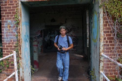
Tim had headed out with me once before, on a trip from Piedmont upstream on the Saluda River. Tim is a naturalist, and a great person to have along on these trips. Today was no different, as we came across lots of wildlife on the paddle.

We first stopped by the Lake Robinson office to get day passes for paddling. Looking out over the more open water of Robinson, we could see white caps churned up by the wind. We had toyed with the idea of just putting in here, but the rough water made us stick with our original plan, and head to the more sheltered waters of Cunningham.

There was a major party wrapping up at the Cunningham picnic area, but the only folks at the boat ramp were a few fishermen who looked at our kayaks skeptically. We launched, then did our usual routine of heading upstream toward the lily pads.

Read More “Quick Jaunt to Cunningham” »

A Matter of Maps

Posted on August 21, 2011 By Tom 3 Comments on A Matter of Maps
Geocaching and Maps, History and Genealogy

Fairfield District

I have been enjoying going through the old maps in the Robert Mills 1825 Atlas of South Carolina. However, last weekend’s photo trek to Old Pickens Court House brought out some problems with relying solely on Mills’ maps to find ghost towns. The maps are too early to catch many towns that developed after 1825, only to fade away by the time of the Great Depression. Never fear, though. There are other online resources that can cover later time periods.

Topographical Maps of South Carolina, 1888 - 1975 - Digital Collections - Thomas Cooper Map Library - USC.png by RndConnections on Aviary

The University of South Carolina’s online digital library has an extensive collection of historic topographic maps of the state. The maps cover from 1888 to 1975, but not all quadrangles are available for this time period. For example, the collection contains three maps for the Abbeville quadrangle – 1900, 1918, 1943. The 236 maps in the collection include a mix of 30 minute, 15 minute, and 7.5 minute projections. I haven’t checked to see how extensive the state coverage is, but I’m sure there are parts of the state that are not covered.

Read More “A Matter of Maps” »

Mekong Vietnamese Restaurant

Posted on August 18, 2011 By Tom No Comments on Mekong Vietnamese Restaurant
Restaurants

While on our photo trek Ed gave me grief about not doing any restaurant reviews lately. And he’s right – I haven’t. It seems that we’ve been either traveling too much, eating at home because we’re tired of traveling, or hitting our tried and true places because we’re too tired to cook but also tired … Read More “Mekong Vietnamese Restaurant” »

Old Pickens Court House

Posted on August 16, 2011 By Tom No Comments on Old Pickens Court House
History and Genealogy

Old Pickens Presbyterian-23

During our photo trek on Sunday, Ed and I visited Old Pickens Presbyterian Church, which was once in Old Pickens Courthouse. The “Old” designation is official, as a way of distinguishing it from the “New” town and church to the east. This location fits our working definition of a “ghost town”, so I thought I would write it up as such.

Ed and I first visited the church early in the morning. The church itself was closed, but there was a sign saying that it would be open at 2:30 that afternoon. After our trek I had dropped Ed off at his house, and was actually on my way home when I noticed the the time – the church would now be open. Since I hadn’t gotten very far down the road, and since I had no idea when I would have another opportunity, I turned around and headed back to the church.

I found the church open and manned by Joyce Brickett, who is on the Board of Directors of the Historic Old Pickens Foundation. She had several tables set up with a wealth of information about the church and the town. I spent some time photographing the interior and talking with her about the area.

Old Pickens Presbyterian Interior

Read More “Old Pickens Court House” »

A Photo Trek with a Duck Hunter

Posted on August 15, 2011 By Tom 1 Comment on A Photo Trek with a Duck Hunter
History and Genealogy, Local, Photography

Newry-10

Saturday I met Marc50. Sunday I met another long-time Flickr friend – Ed Clem, the Duck Hunter.

Ed and I have been online friends for several years now.  We started commenting on each other’s photos first on Flickr, then started following and commenting on each other’s blogs, and have both been active on Facebook and Google+.  I feel like I know Ed fairly well, but there’s just one catch – we had never met in person.  That is, until Sunday.  Ed loves history and rambling about as much as I do.  So we decided to get together and see what we could find in the Pickens-Oconee areas.

I picked up Ed at his home, then we headed for our first stop, Cateechee.  This is an old mill village that has suffered the fate of so many in the upstate.  The mill has closed, and has now been torn down.  The little community has long been in decline.  There are still two churches with active congregations, but any form of commerce is long gone.

Cateechee is an isolated village where the mill is the only real employer, similar to Slater, Newry or Startex.  As one enters the main village loop, the old Cateechee School can be seen off to the right.

Read More “A Photo Trek with a Duck Hunter” »

Another LCU Edisto Day

Posted on August 15, 2011 By Tom 1 Comment on Another LCU Edisto Day
Paddling

LCU on the Edisto

The Edisto River has become home base for Lowcountry Unfiltered (or, at least, it runs a close second to the Savannah.) We try to paddle it at least twice, sometimes three times a year. Each section has its own characteristics. The stretch from Mars Old Field to Givhen’s Ferry is the “party stretch”, with float bubbas, rope swings, and who knows what else. The stretch we paddled Saturday has wildlife of a more traditional type. From Stokes Bridge to Mars Old Field one encounters one of the more remote parts of the river, with very few houses lining the banks. This particular trip we saw lots of wildlife, from osprey to herons and egrets to enormous carp trying to jump into our boats.

Our group was smaller than usual, only 10 paddlers, but we also had some new faces. I’ve known Marc Epting for years as Flickr photographer Marc50. Marc takes some great photos around his hometown of Columbia and the Midlands, but I was attracted to his photos because he uses the same camera I do – an aging Nikon D50. We also had a couple more newbies from the lowcountry join us. I hauled down two spare boats to accommodate the crowds.

LCU Group Shot

Read More “Another LCU Edisto Day” »

Millstone Mystery

Posted on August 8, 2011 By Tom No Comments on Millstone Mystery
History and Genealogy, Local

Last Friday afternoon I was copied on an e-mail from my boss regarding a discovery. This summer they are doing some sewer work at Reidville Elementary School, and according to the e-mail the construction workers had dug up an old mill stone behind the school. The e-mail was addressed to the principal of the school, … Read More “Millstone Mystery” »

Robert Mills’ Atlas of South Carolina

Posted on August 4, 2011 By Tom 8 Comments on Robert Mills’ Atlas of South Carolina
Geocaching and Maps, History and Genealogy

State District

I was talking with my brother Houston sometime back about my Ghost Towns project, and he suggested that in addition to using the GNIS historical data, we should look at old maps of the state to see what towns might have been listed. I agreed that it was an excellent idea, so I set off in search of the one resource I knew would have everything we wanted – Robert Mills‘ 1825 Atlas of South Carolina.

A native of Charleston, Robert Mills was the quintessential Renaissance Man, along the same lines Thomas Jefferson. Mills studied architecture first in Charleston, then later in Philadelphia. Anyone familiar with South Carolina history is aware of Mill’s contributions to South Carolina – the many court houses and civic buildings designed by him. Perhaps, though, he is most famous for his designs for buildings in Washington, D. C., including the Washington Monument.

In 1818…

“…the General Assembly adopted resolutions looking to the preparation of a map of the state, showing a separate map of each district thereof. In 1818 an appropriation of $9,000.00 was made toward procuring such a map, and in 1819 a like amount was appropriated for the same cause.”

-from the Introduction to the 1839 reprint of the Mills Atlas.

In 1820 Mills was appointed commissioner for the Board of Public Works for South Carolina, and was tasked with creating the atlas. He commissioned surveyors to create the separate maps for the then 27 districts in the state. He then personally rescaled the surveyors’ work for inclusion in the atlas, and added a legend reflecting the new scale. He also edited place names, adding or omitting as needed. The legend of each map bears the original surveyor’s name and notes the map was “improved for Mills’ Atlas, 1825.”

Greenville District

Read More “Robert Mills’ Atlas of South Carolina” »

Matching Reality to Google Earth

Posted on August 3, 2011 By Tom No Comments on Matching Reality to Google Earth
Geocaching and Maps

In Flight Photos-2

No matter how many times I’ve flown, the concept of this massive machine lifting into the air still strikes me as weird. I’m still fascinated. And unlike those jaded fliers who prefer the aisle seats, I still like to look out the windows at both the ground below and at unique cloud formations.

This summer I took a couple of trips across country, so I’ve had plenty of opportunity to look out windows. On the past several trips it’s struck me how similar the view is to Google Earth, and I began to wonder if I could match up locations with the same spots in Google Earth.

So, I grabbed my camera and started snapping out the window, trying to see if this could be done. Turns out it’s much, much harder than you might think.

Read More “Matching Reality to Google Earth” »

Quick Update

Posted on August 1, 2011 By Tom 2 Comments on Quick Update
Miscellaneous

I really hate these kinds of “weekend update” types of posts, and only do them as a last resort.  I feel that little blurbs about my day-to-day activities are best left to Twitter, Facebook and the like, where I would deeper explorations here.

Regardless, the last week of July is always a nightmare, and I haven’t had much of a chance to catch my breath, much less write a long blog post.  Here, then are a few things that have happened recently, for those that might be remotely interested…

Read More “Quick Update” »

Categories

  • EdTech (200)
  • Entertainment (201)
  • Family (120)
  • Gear (115)
  • General Technology (99)
  • Geocaching and Maps (208)
  • History and Genealogy (260)
  • Internet (144)
  • Local (449)
  • Miscellaneous (544)
  • Music (194)
  • Paddling (245)
  • Photography (779)
  • Podcast (6)
  • Rambling (226)
  • Rants (160)
  • Recipes (34)
  • Religion (48)
  • Restaurants (165)
  • Science (48)
  • Things Overheard (29)
  • Travel (410)
  • Uncategorized (129)
  • Washington Sabbatical (113)
  • Weirdness (60)

Recent Posts

  • Wilkinsville and a Mystery Church
  • A Farewell to the Greenville Chorale
  • Edisto River from Good Hope to Sullivan’s Landing
  • Paddling Lake Monticello
  • The Remnants of the City

Recent Comments

  • Kim Atchley on Journey to Nazareth
  • Tom on About Us
  • drew seibert on About Us
  • Doris Street on Orphaned Graveyards and Family Connections in Ninety Six
  • Tim Cathcart on Wilkinsville and a Mystery Church

Tags

blogging cemetery Christmas Columbia Edisto River edtech Entertainment family Flickr Florida Furman Furman University gear Georgia geotagging Ghost Town Ghost Towns Google Earth Google Maps GPS Greenville Greenville Chorale history Instructional Technology kayaking Lake Jocassee LCU Lowcountry Unfiltered maps Music North Carolina Paddling Photography rambling restaurant Restaurants review singing social networking South Carolina time-lapse Travel video Washington Washington State
August 2011
S M T W T F S
 123456
78910111213
14151617181920
21222324252627
28293031  
« Jul   Sep »

Copyright © 2022 Random Connections.

Theme: Oceanly by ScriptsTown